In the canals, too much mud can be a problem, but one doesn’t see it until the extreme low tides of mid-winter. When anyone asks me how deep are the canals, I usually ask “You mean at high tide? Or low tide?” The height of the water changes, but over time so does the height of the mud.
You could call it the lagoon’s base layer. There are places where there’s too much mud, mainly in the canals; it accumulates and creates problems for boats when the tide is low and, equally important, problems for buildings whose drains it has blocked, and so we have to take it away.
But there is an equal and opposite problem of there not being enough mud in places around the lagoon, where dredging has been heavy or, more frequently, where the motondoso (waves from motorboats) has loosened the soil, and the tide and waves have washed it out to sea. Waves that demolish the wetland marshes (barene) or, on the other hand, fill up channels, have been known for years to be wrecking the lagoon’s wrinkly underwater shape, smoothing it out and slowly turning it into a sort of bay of the sea. Bays of the sea are an entirely different ecosystem from lagoons, but no matter! Motors are indispensable for keeping the city going, and the lagoon is just going to have to suck up (so to speak) the consequences.
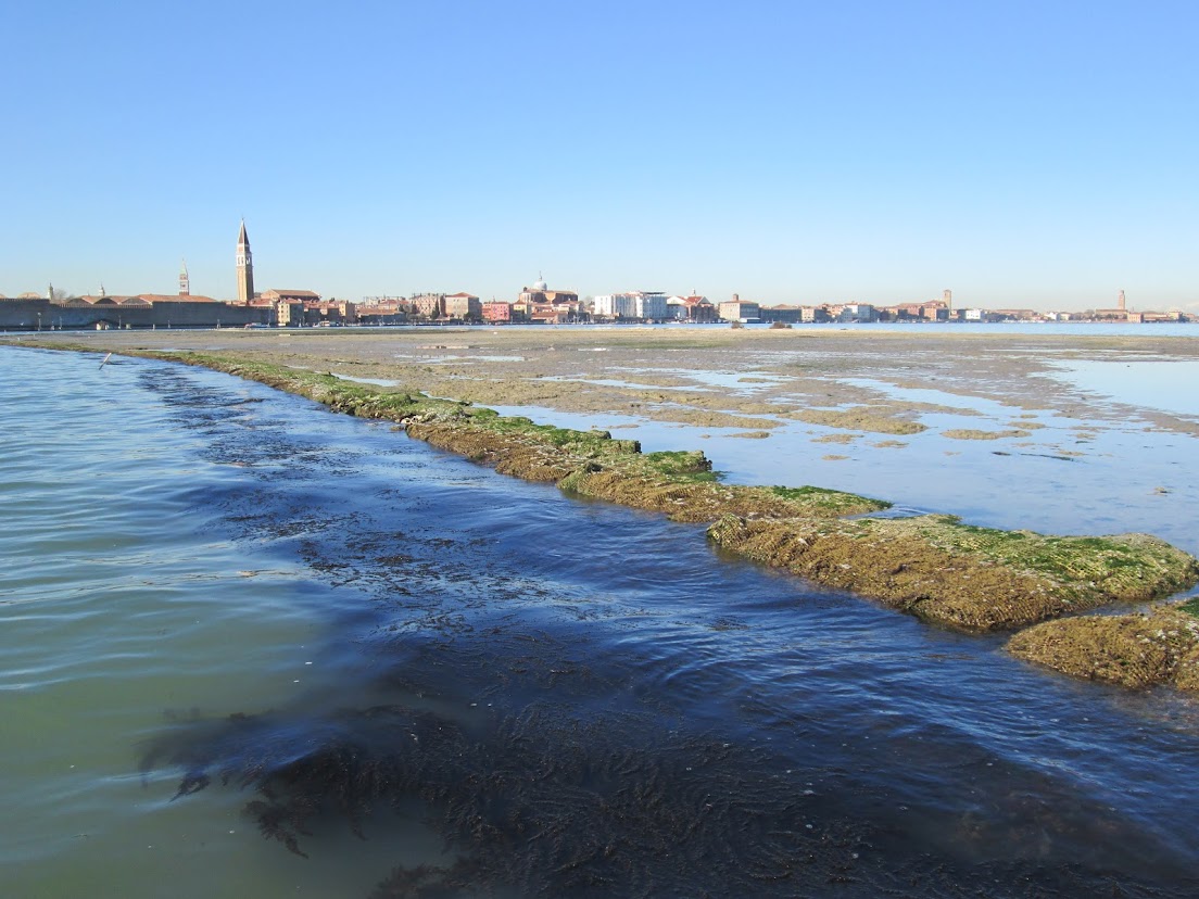
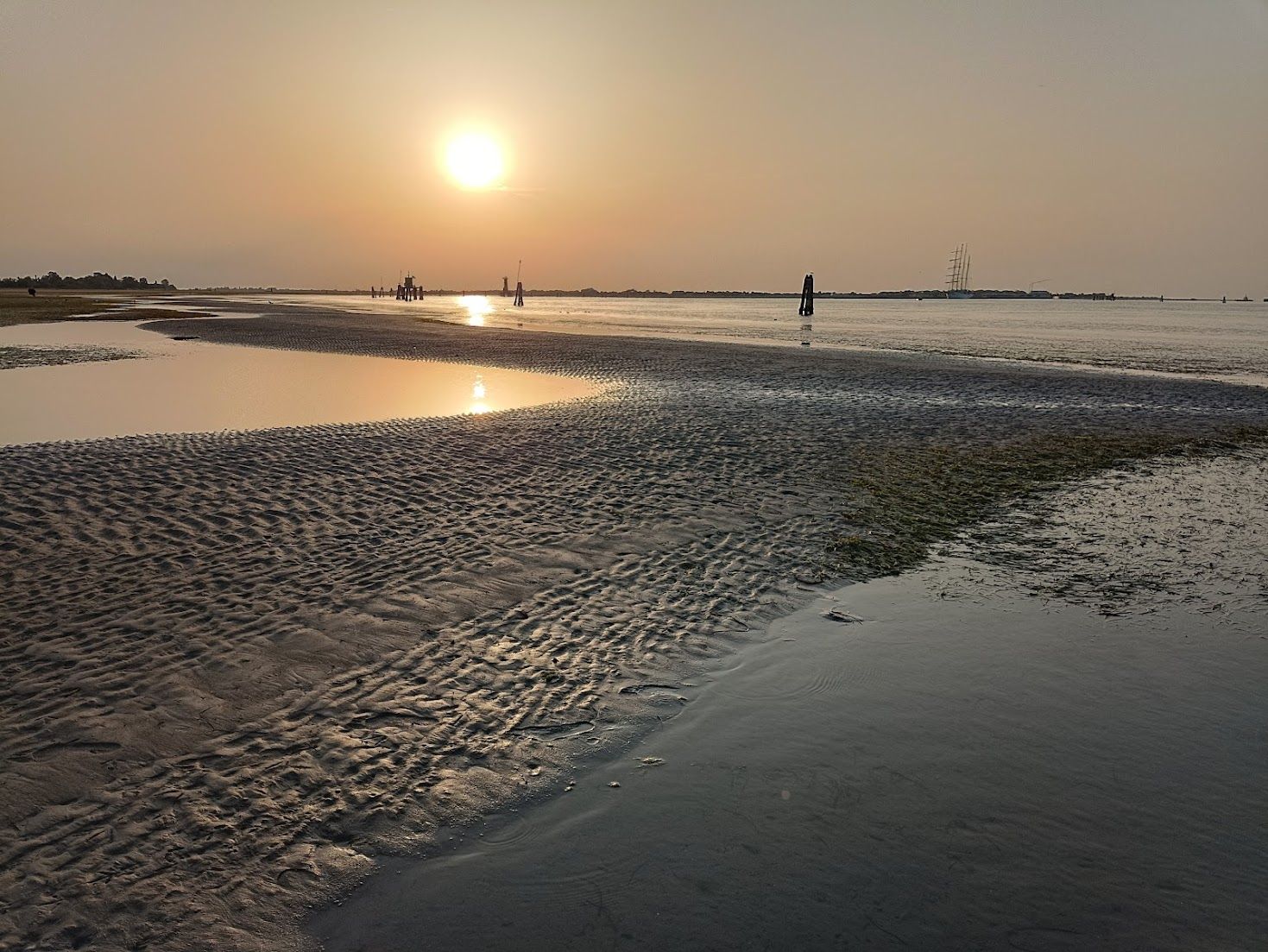
At water-level you may notice only water, but the lagoon is full of mud.
The 17th-century Venetians knew the lagoon dynamics intimately. Their survival depended on it. Fears of the lagoon silting up from the several rivers that flowed into it led them to an epic undertaking: From 1600-1604 they cut the river Po to divert it southward into the Adriatic.
In 1993 it was decided to redistribute the quantities of mud in the city and lagoon: Simple, logical, effective, positive. Dredging proceeded and the mud was deposited in various locations where it was useful, or at least not problematic. In fact, moving mud around is far from a recent phenomenon — it’s been done many times over the centuries resulting in consolidations, expansions, and entire new islands. This assortment of maps showing the Morphological Evolution of the Lagoon of Venice from the XVI Century till today is very interesting. In the 20th century Tronchetto and Sacca Sessola, to name only two, rose from the lagoon bottom created with dredgings.
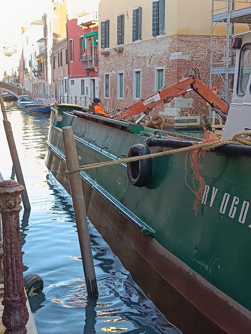
And so, in the fullness of time, the dredges were at work outside our door in 2021, and they were at it again just two months ago. All seemed to be going well, but suddenly we read that things have taken an unexpected turn. The mud is unusable!
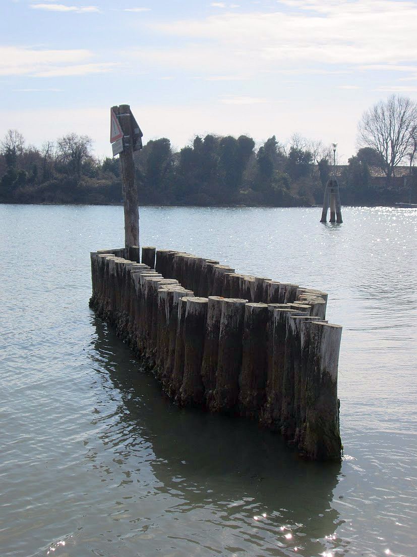
The dredger the first day of work thought it was a good idea to tie his behemoth to one of our little pilings to resist the weight of the mud he’s pulling up. He was wrong. But you can appreciate something about the mud here: It’s tenacious. Once it grabs onto something, it really doesn’t intend to let go. This went on for hours, the modest pole yanked sideways, as you can see; it simply couldn’t be dislodged, although it’s now a bit shaky. The next day he moored the monster to the metal ring on the street, and we’re trying to help our piling begin to trust people again.
The headlines have been blunt: “Unusable muds, the lagoon in crisis, the dredging has been stopped in the lagoon.” “The new Protocollo of 2023 for the sediments dug in the canals doesn’t work anymore because the parameters of ecotoxicity are too rigid.” “First they were considered clean and good for reconstructing the barene. But no more: Now there’s a risk of blocking also the dredging of the most polluted.”
This problem has come up literally in mid-dredge. It’s a little awkward to discover that the Protocollo of 2023 is invalid when the barges are full of mud, so now what? Is there a Plan B? “Strictly speaking, we don’t have one,” to quote CIA operative Gust Avrokotos in the film “Charlie Wilson’s War.” “But we’re working on it.”
So what changed all of a sudden? It’s that, as the headline noted, the standards are suddenly stricter as to what mud is classified as “ecotoxic” (either biological or chemical) and therefore where it can be dumped. (Don’t write in, I know that everything is chemical, looking at the universe. We’re roughly distinguishing here between chromium and E. coli.)
Nobody’s surprised to hear that there are toxic substances in the lagoon — just look at the Industrial Zone shoreline and draw your own conclusions. A few years ago the University of Padova and Ca’ Foscari in Venice studied some mollusks taken from the channel bordering the mainland. Researchers found that the bivalves contained a quantity of poisonous substances 120 times higher than in the rest of the lagoon.
So here we are. Where will the mud go?
Men used to do this with shovels. Not underwater, of course.
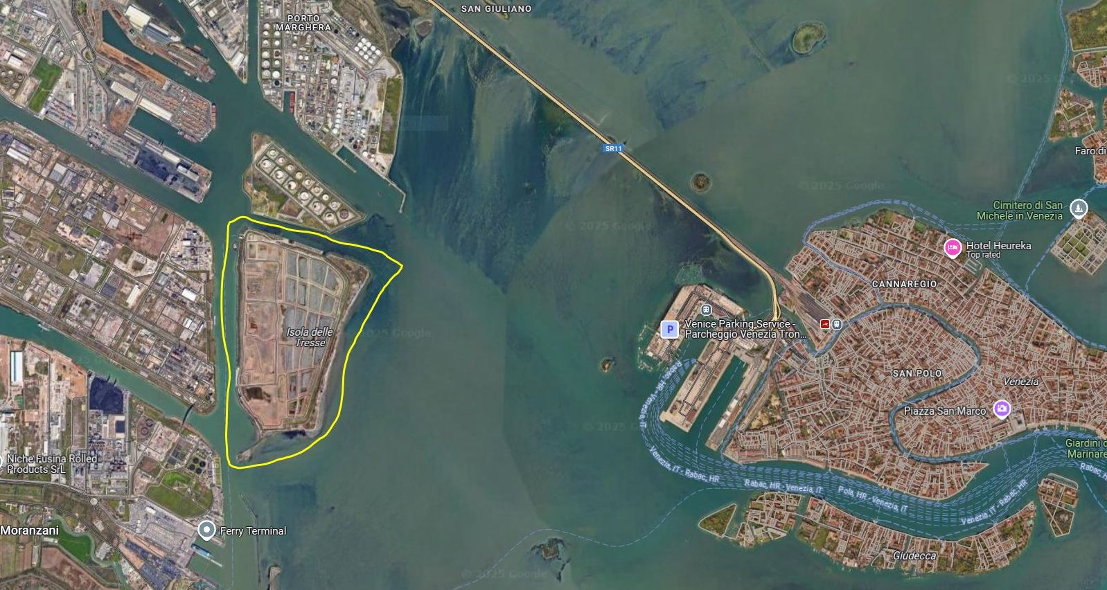
All muds are not created equal. Category A, the cleanest kind, is safe to put under the water, so it can be used “nourish” the shrinking barene. Other muds, the more toxic Category B and C, can’t be put back into the lagoon, no matter how worthy the reasons, and have to be banished to the Tresse island. And God forbid all these muds should become mixed together. Burning the mud is an interesting proposal, but it’s hard to agree on where to put the ash.
Also, the Tresse at the moment is running out of space. There have already been discussions about enlarging it, but quantity and quality, as often happens, are in conflict. Decisions lag. Bureaucratic, legal, logistical issues keep bumping into each other. Cost must be in there too, somewhere. The Morphological Plan of the lagoon was shot down in 2022 and nothing has been heard of it since.
The Isola delle Tresse began in the 1930’s as Storage Tanks island, and was expanded in 1993 with a million cubic meters of mud and other material dredged for the benefit of the Port of Venice. This raised the island by nine meters (30 feet) and doubled it in size. Now it has been proposed to deposit as much as an additional four million cubic meters of mud, which would raise the island as high as 13 meters (43 feet). May I take just a moment to recall that when UNESCO designated Venice as a World Heritage Site in 1987 it also included the lagoon? Toxic mud doesn’t sound very World Heritage Sitey.
So, back to the dredging at hand: After weeks of hardy gouging and hauling, the mud’s permission to land, so to speak, has been revoked. The Department of You Should Have Seen This Coming isn’t answering its phone.
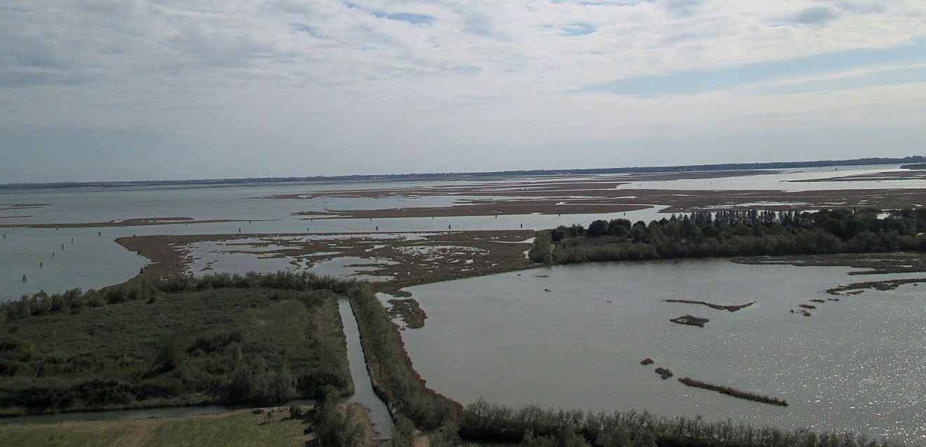
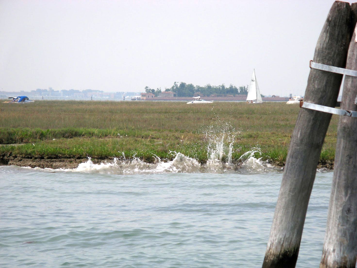
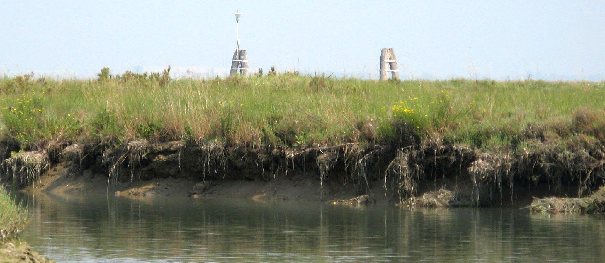
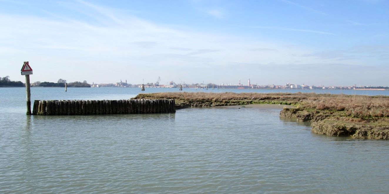
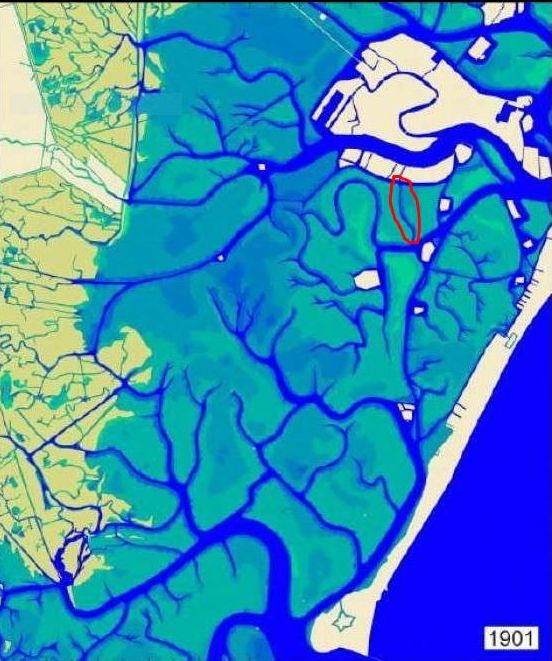
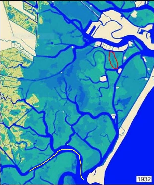
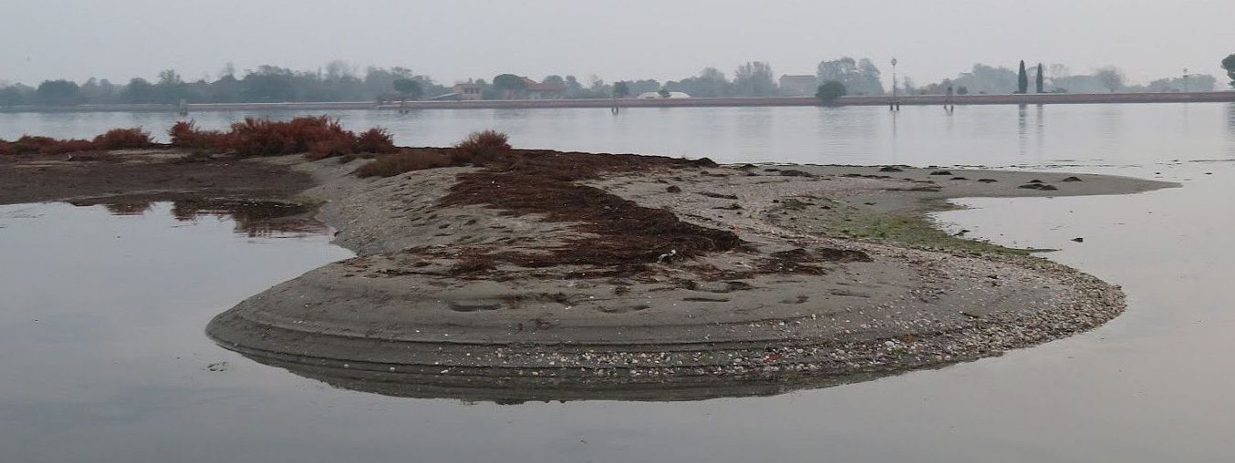
The barene (semi-solid mud) are beautiful and crucial to the whole ecosystem. But motondoso, or waves caused by the anarchy of motorboats, slices away at their soft soil. This goes on all year long, but especially in the summer. Note the distance between the wooden piling and the islet. They used to be much closer together. Shrinking barene aren’t good for the health of the lagoon as a whole.Of course the plant roots help stabilize the soil, but they only go down so far. Soon the upper layer will collapse and slide into the water, filling up the channel. We need the barene and we also need the channels, but they do not play well together. Eventually there will be too much mud in the channel, and not enough island, and dredging will be called for. And perhaps expansion afterward. Not literally inconceivable.To resist the waves gnawing at the barene, various defenses have been tried. Above is somebody’s idea of a breakwater. The barena is clearly not reacting as the planners intended. You can see here why it was hoped that the latest batches of dredged mud could enlarge shrinking bits of land, because more and/or larger barene would be a great thing for the ecosystem. Even if you don’t care about the ecosystem — I don’t judge — more barene would serve as barriers to slow the incoming tide, the way they always did before motondoso began to tear them apart.This construction is not destined to last long; the team behind this project seems not to have observed what happens to wooden pilings in the water.The lagoon loses 600,000 cubic meters of sediments every year, leaving an increasing wasteland behind. You can easily see the difference between the lagoon north of Malamocco (divided by the Canale dei Petroli, about which more below), and the southern lagoon. If too much mud in one place is a problem, too little mud in another isn’t any better. Fewer barene and fewer channels mean the water can rampage around and carry even more mud away with the tide, or deposit it unhelpfully elsewhere.1901. We see lots of squiggly channels back then (which, like the barene, slowed down the tide, and the dislodging of sediments). You also see that the shoreline was squishier and more ragged, providing more space for the water to come and go, moving more slowly in the process. But too many channels were doomed, like the little one circled in red above.1932. Look at the little channel (ghebo, in Venetian) circled in red again. You see that natural processes have caused it to begin to fill in, but it was still in good shape at least ten years later because Lino remembers it well. His father would take him out fishing in their little boat and they rowed along this canal on their way to the best spot to “dig” for canestrelli, or little lagoon scallops (Aequipecten opercularis). Note: The different colors indicate varying depths of the water. You’ll see that change over the decades too.
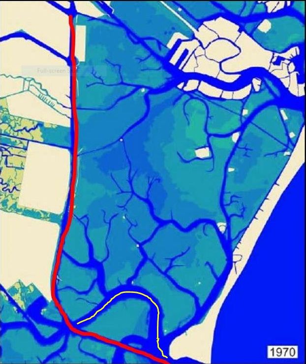
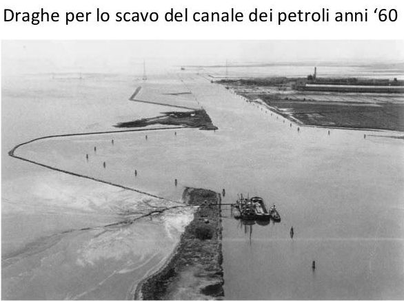
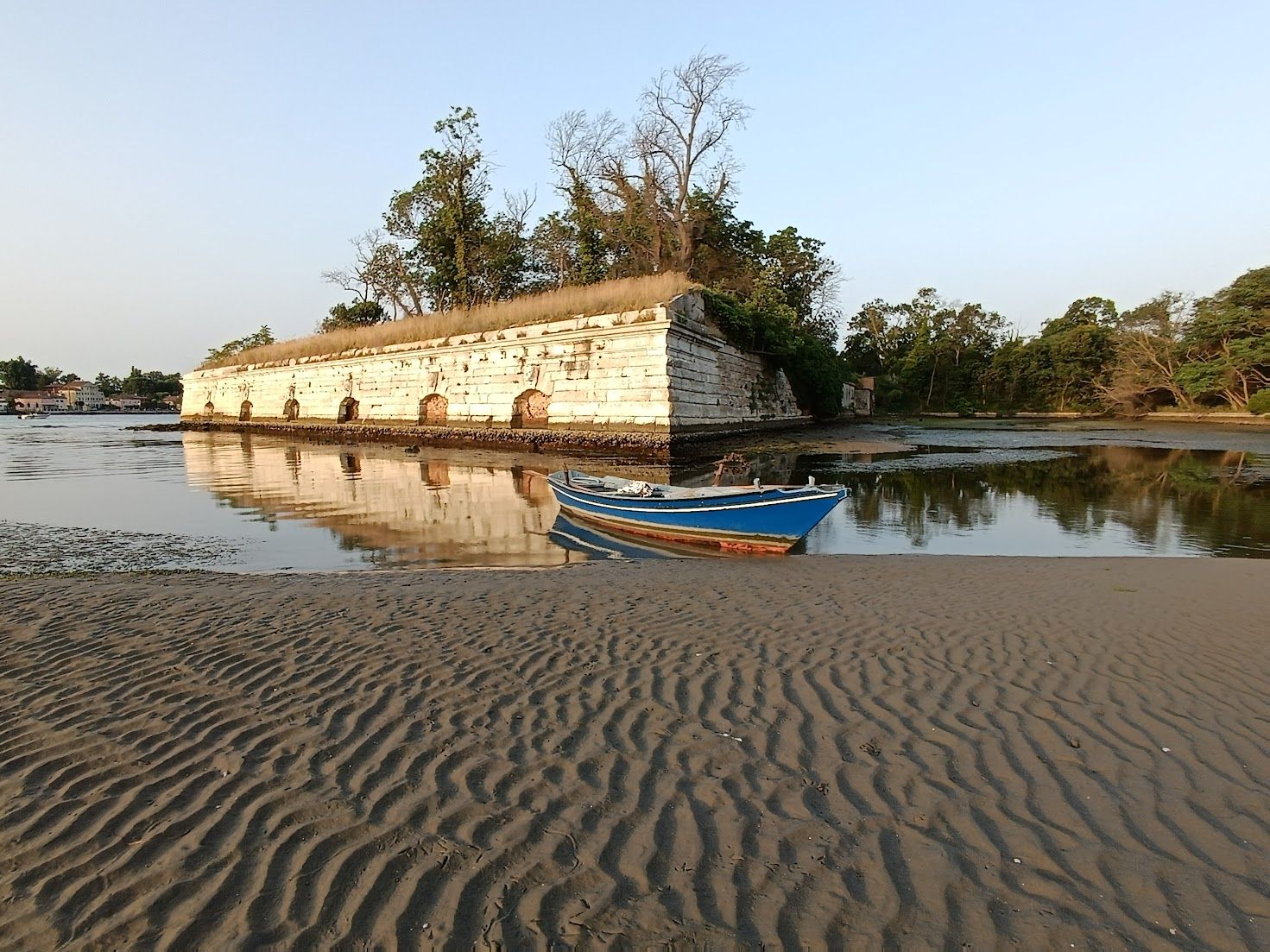
In the Thirties the Industrial Zone was being built; for Venice’s post-war economy it seemed like the greatest plan ever, and in many ways it was. In their great days (now past), the chemical refineries here were the largest in Italy. Oil and chemical industries require raw materials, and those require ships, and ships require reliable channels for passage. That broad, curving channel marked in yellow on the map above that enters the lagoon from Malamocco does not look like anything a big ship would want to navigate, and of course ships also need a waterway to reach the mainland port area. And so the Canale dei Petroli (“petroleum canal,” in honor of the expected tankers) was planned.
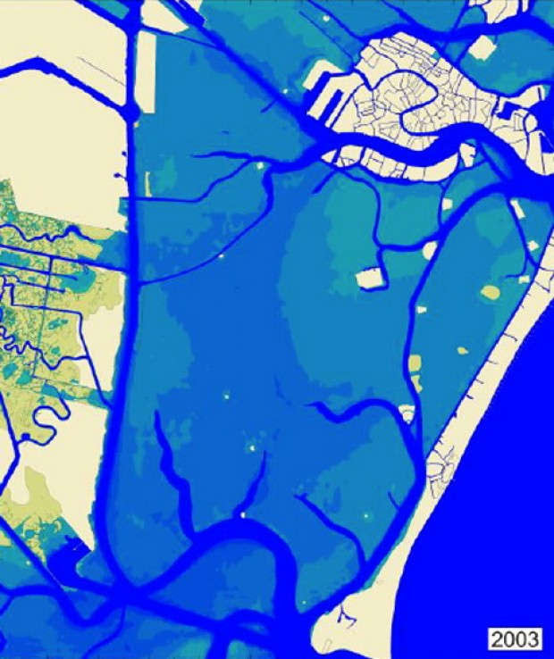
1970. The triumph of the shipping. The broad, curvy yellow channel (which also slowed the force of the tide) was bypassed in 1964-1968 by the digging of the channel that is straight as an airport runway: The Canale dei Petroli. The resulting tons of mud went to the shoreline, reshaping it by the formation of three longish islands (generically called casse dicolmata) that were created along the flank of the mainland. They were intended as the land for the Third Industrial Zone, which was never built. Left to their own devices, they’ve become a sort of oasis, especially for birds.Dredging the Canale dei Petroli created a channel 18 meters (60 feet) deep, 15 km (9 miles) long and 200 meters (656 feet) wide. If you had wanted to suck the sediments out of the lagoon, you could hardly have done better. But the wakes of the cargo ships also stir up the sediments and they don’t all reach the sea. Result: More dredging is needed periodically as the channel proceeds to silt up. Further result: The tide entered faster and with more force than ever before, and before you could say “Worst flood in Venice’s history, November 4, 1966” the city went under. Venetians weren’t slow to see a connection between the canal and the flood, but what was done was done.And this is more or less the situation today.Moving mud means moving water. These maps were made in 2009, so the situation may well have changed yet again since then. Looking at you, effects of MOSE. (On the right panel: This map was assembled for study use of the Committee of Public Health of Venice, from the pages published on the site https://www.istitutoveneto.it/flex/cm/pages/ServeBLOB.php/L/IT/IDPagina/1. Credit and rights to this work belong to Diego Tiozzo Netti. The indications of the tidal flows are by Umberto Sartori.)
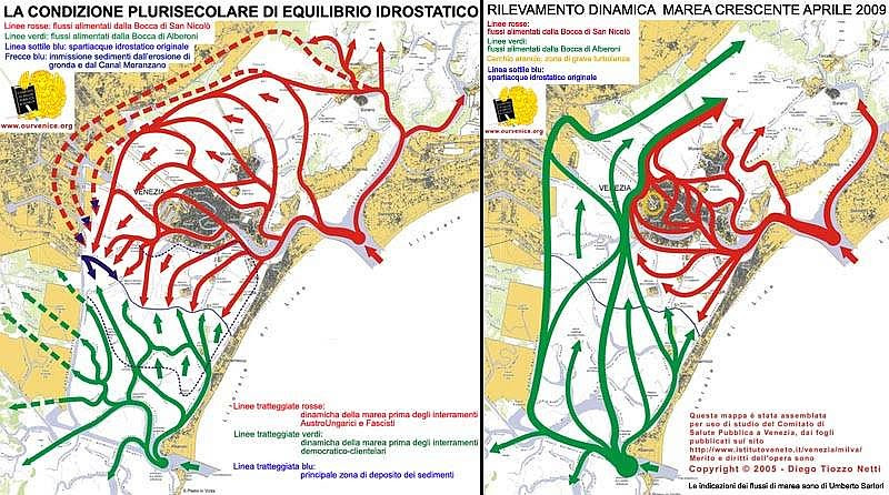
We’re looking at tide patterns, otherwise known as the hydrostatic equilibrium of the tides in the lagoon over many centuries.
LEFT PANEL: The solid red lines show the tidal pathway from the inlet at San Nicolo’. The solid green is the water entering from Malamocco (Alberoni). The thin blue line across the center of the lagoon emphasizes what we can see where the arrows meet, the point where the two incoming tides form the spartiacque, or “division of the waters.” The dotted red lines show tidal flow before the landfills created by the Austro-Hungarians (who left in 1866) and Fascists (1922-1943). The dotted green lines show the tide before the landfills made by the post-war “democratic-clientele governments.” The dotted dark-blue lines are the principal zones of sediment deposits, which makes sense considering the movement of the tides.
RIGHT PANEL: The pattern of the rising tide in 2009. The solid red line shows the pattern of the tide entering the lagoon from the inlet at San Nicolo’. The solid green line shows the tide entering from Malamocco (and, obviously, along the track of the Canale dei Petroli.) This graphic shows the effect of losing the mudbanks, natural channels and barene, smoothing out the lagoon bottom that used to be naturally uneven and knobbly.
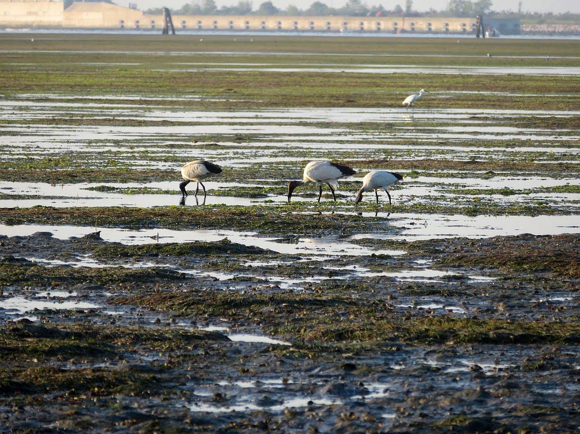
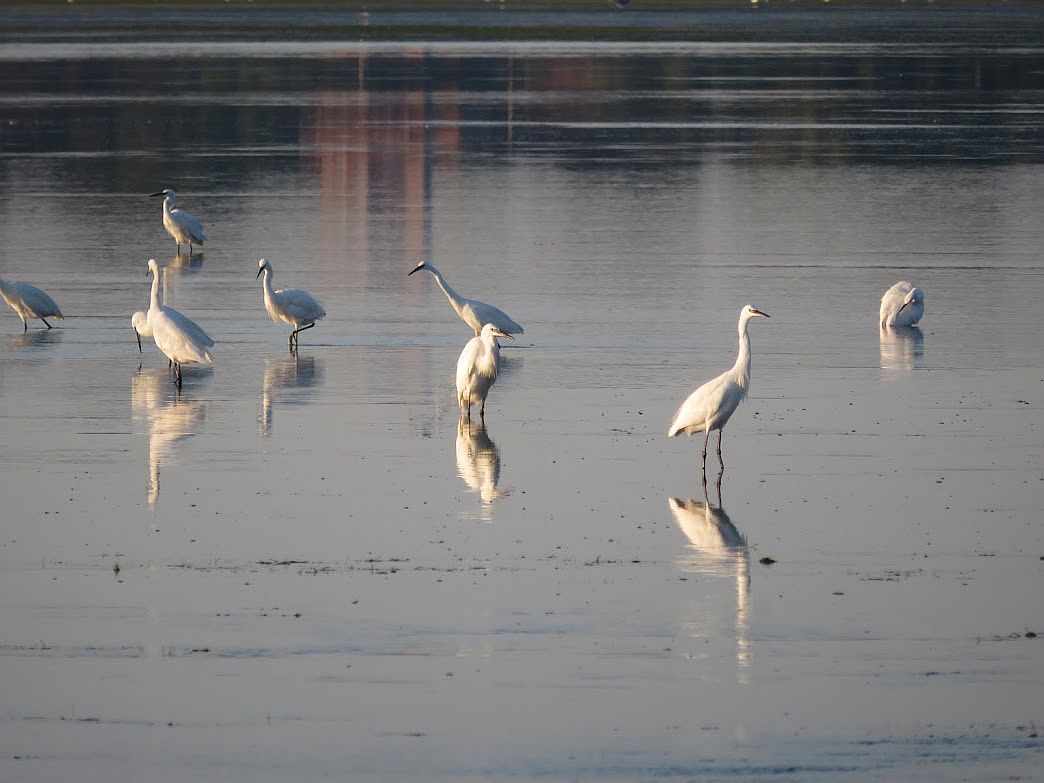
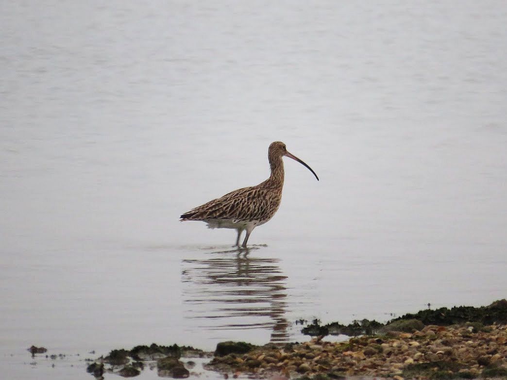
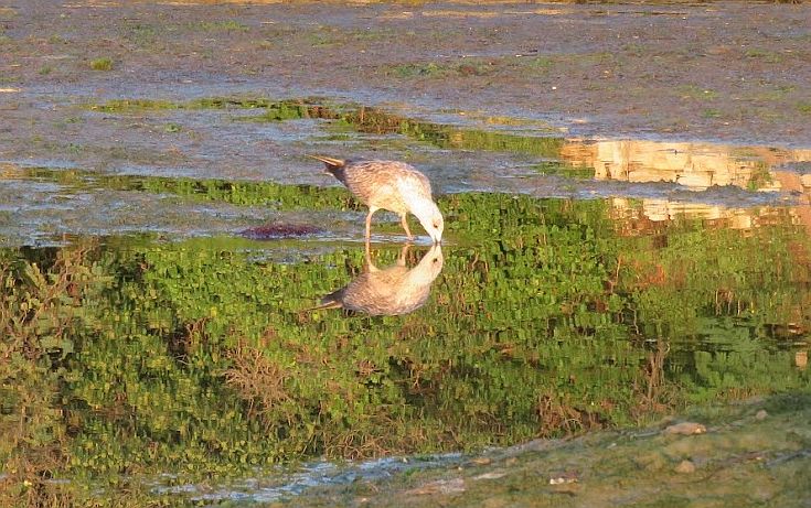
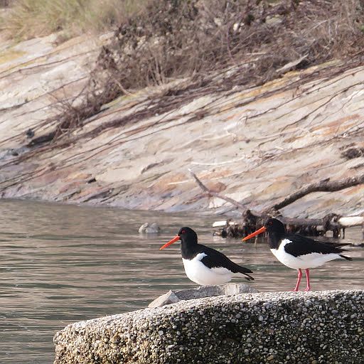
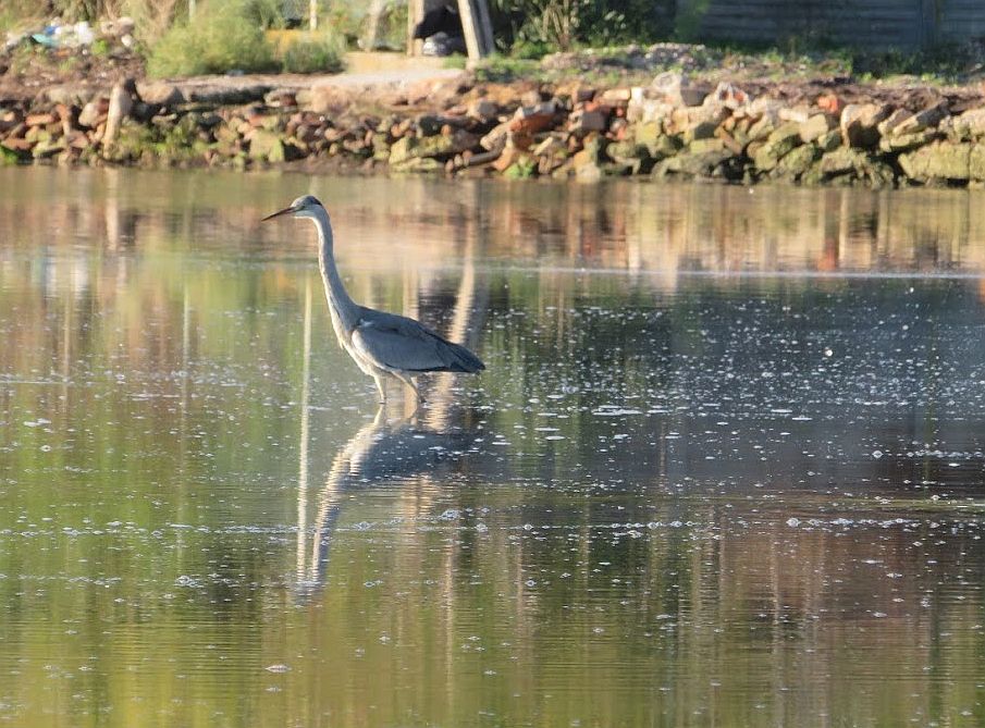
I think the tides and the mud matter more to many other creatures than they do to mere humans. This barena that was built next to the Certosa island is a haven for flamingoes, Eurasian oystercatchers, egrets, herons, common shelducks, and the now-ubiquitous sacred ibis. And undoubtedly more that I haven’t discovered yet.The ibis (Threskiornis aethiopicus) love the mud.Snowy egrets (Egretta thula) don’t particularly care about mud, per se, but they like the easy fishing when the water is shallow.Curlews (Numenius americanis) absolutely love the mud, digging up worms and other little submerged treats.The plover (Pluvialis squatarola) is another huge fan of mud.The oystercatcher (Haematopus ostralegus) is really beautiful, unless you’re an oyster, obviously. They also wade around looking for mussels and earthworms.The grey heron (Ardea cinerea) is the apex wader. Evidently he’ll eat almost anything.Here the lagoon bottom is fairly firm when it’s exposed at low tide, but if you walk into the water you will sink into squishy mud up to your ankles. Pause to admire the tracks of the birds who have traversed this territory, snacking to their heart’s content.
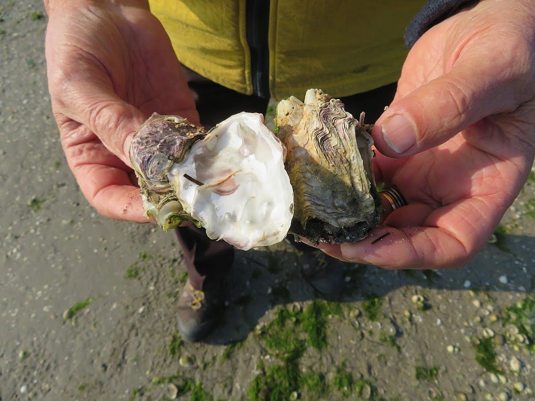
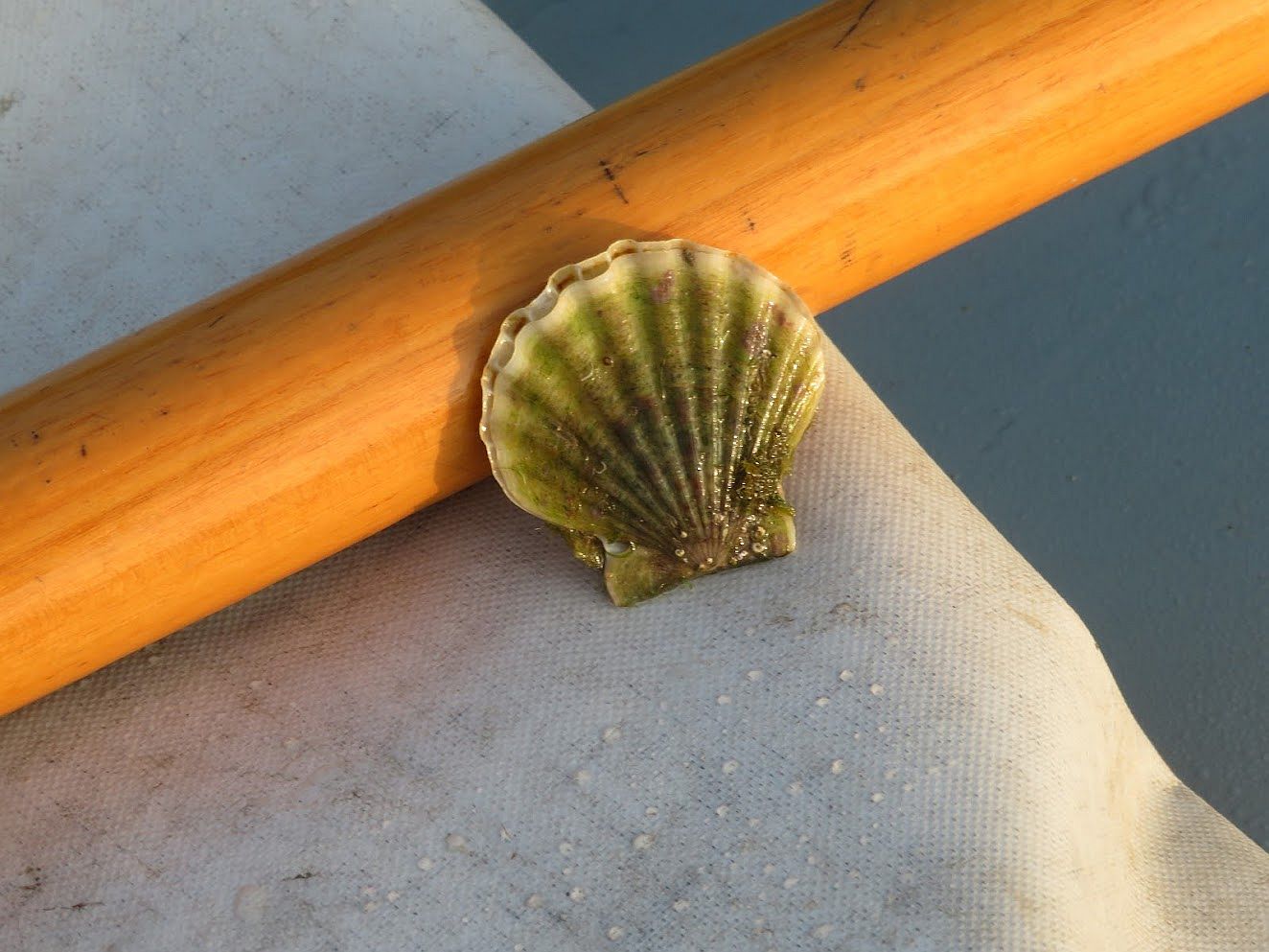
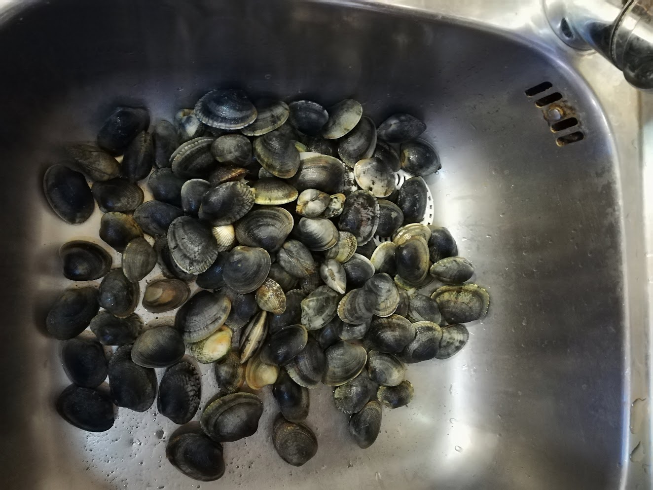
The important thing is that the lagoon bottom isn’t perfectly flat.This is evidently the perfect place for a feast. The shore is littered with clam and oyster shells, the casings of creatures that need the mud to live.The mud doesn’t just feed the birds. There are indeed oysters in the lagoon and they are delectable. Lino spent one Christmas Eve afternoon out in the lagoon and brought home a batch of these for our dinner. These three clutched together, though, seem to have formed a sort of Wagnerian pact or something.We sometimes find scallops, even though they’re not as plentiful as when Lino was a boy and would go home with a bucketful.That was a good day out — lots of different types of clams (and this isn’t all of them, by any means). They may be pondering how unmuddy the world has suddenly become.Regard the mud. The waves from some passing boats clearly show that the mudbank is just below the surface.You see water, I see mud. The surface is smoother where the water is shallower as the tide rises or falls. If you’re out rowing and you see this, you have only yourself to blame if you run aground. You were warned.
If you want a lagoon, you have to want mud. Otherwise you might just as well look at your bathtub.
Fascinating information about the lagoon. You did a lot research I think. Really appreciate your posts about Venice and its lagoon. I don’t know where I could find this kind of knowledge. Makes me appreciate Venice as a “real” place. Not just an over touristy city. Thanks.
Thanks so much, George. I was hoping you’d respond this way. I don’t mean by writing to me, in itself, though that’s always wonderful. I just mean that that you appreciate my scribbles.
I lived for fourteen years in a tidal area, with a geological framework of granite, sand, salt-marsh, and mud, with a tide of eight or nine feet, which made for extremely dynamic hydrology. There was drama (and danger) in the narrow estuary, and dramatic daily change in the vast perimeter mud flats and beaches. Thanks for reminding me of that fascinating environment, and for making the subtle details as fascinating as the drama.
As always, super research, so well organised, thorough and well-expressed. It’s a delight to see the English language so well used, and your illustrations and examples are easily understood and so informative. It always seems a long time between your writings, but they are so well-worth waiting for. All I’ve ever noticed is when we have seen individual canals being excavated and dredged, and we had no idea about the toxicities of different forms of mud.
Thank you, yet again. We are clearly members of the Erla Appreciation Society, with so many others.
Ella B
This article is a real masterwork. The information is precise, scientific and totally reliable. There is a lot of research (and of love) behind the apparent simplicity of the language. The pictures are magnificent, certainly taken in years of lagoon crossing on rowboats. This is a plea more eloquent than so many documents prepared by associations and protesters about the sad conditions of the lagoon. Thank you for your work!
Fascinating and beautiful as usual, Erla. The lagoon is a real paradise, especially in those early mornings. I can’t wait to be back. Speaking of mud, I hope that the dredging of the Rio Sant’Anna was completed in an uneventful way and that your little boat is back in a mooring post where no acrobatic skills are needed for embarkation.
“Erla & Lino Appreciation Society” has a Swedish chapter too! 🙂
Thanks Andreas! The dredging itself has concluded but in fact the dredgers left a slim metal piling stuck in the mud right behind our boat. One day it was just there, and it probably will be there forever. Why? What for? It’s like a freaking squatter that is impossible to evict. We manage to maneuver around it, but it doesn’t have any reason to be there. And yet there it is. Thanks for asking.
Brava Erma! Your prose, photos and well researched writing is admired by both of us. Thank you so much for bringing these important details of Venetian life to our attention.


12 Comments
Fascinating information about the lagoon. You did a lot research I think. Really appreciate your posts about Venice and its lagoon. I don’t know where I could find this kind of knowledge. Makes me appreciate Venice as a “real” place. Not just an over touristy city. Thanks.
Thanks so much, George. I was hoping you’d respond this way. I don’t mean by writing to me, in itself, though that’s always wonderful. I just mean that that you appreciate my scribbles.
Wow. Another fantastic post – well- researched, informative, beautiful, funny, human. Thanks so much Erma. Made my day brighter.
Good heavens — what a great compliment. Thanks!
I lived for fourteen years in a tidal area, with a geological framework of granite, sand, salt-marsh, and mud, with a tide of eight or nine feet, which made for extremely dynamic hydrology. There was drama (and danger) in the narrow estuary, and dramatic daily change in the vast perimeter mud flats and beaches. Thanks for reminding me of that fascinating environment, and for making the subtle details as fascinating as the drama.
I can not believe the amount of effort, research and dedication that went into this article. I have enjoyed your writings for years! Thank you.
As always, super research, so well organised, thorough and well-expressed. It’s a delight to see the English language so well used, and your illustrations and examples are easily understood and so informative. It always seems a long time between your writings, but they are so well-worth waiting for. All I’ve ever noticed is when we have seen individual canals being excavated and dredged, and we had no idea about the toxicities of different forms of mud.
Thank you, yet again. We are clearly members of the Erla Appreciation Society, with so many others.
Ella B
This article is a real masterwork. The information is precise, scientific and totally reliable. There is a lot of research (and of love) behind the apparent simplicity of the language. The pictures are magnificent, certainly taken in years of lagoon crossing on rowboats. This is a plea more eloquent than so many documents prepared by associations and protesters about the sad conditions of the lagoon. Thank you for your work!
Fascinating and beautiful as usual, Erla. The lagoon is a real paradise, especially in those early mornings. I can’t wait to be back. Speaking of mud, I hope that the dredging of the Rio Sant’Anna was completed in an uneventful way and that your little boat is back in a mooring post where no acrobatic skills are needed for embarkation.
“Erla & Lino Appreciation Society” has a Swedish chapter too! 🙂
Thanks Andreas! The dredging itself has concluded but in fact the dredgers left a slim metal piling stuck in the mud right behind our boat. One day it was just there, and it probably will be there forever. Why? What for? It’s like a freaking squatter that is impossible to evict. We manage to maneuver around it, but it doesn’t have any reason to be there. And yet there it is. Thanks for asking.
Brava Erma! Your prose, photos and well researched writing is admired by both of us. Thank you so much for bringing these important details of Venetian life to our attention.
Auto corrected to Erma…. I meant ERLA!!!