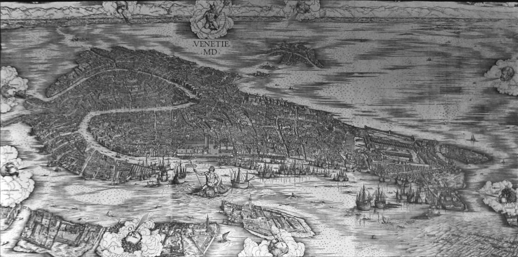
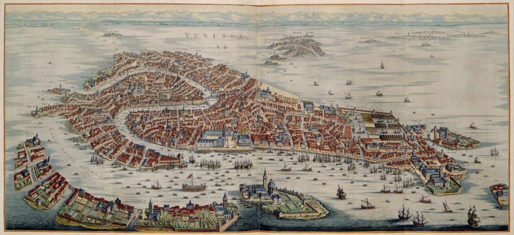
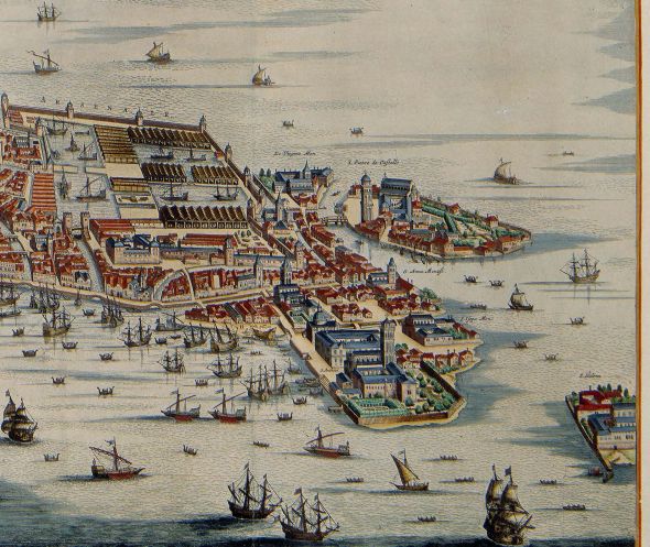
Jacopo Dei’ Barbari published this phenomenal map in 1500 after three years of hard labor. It remains the gold standard for maps of 16th-century Venice; he has managed to include every single building and canal then in existence. The only drawback is the lack of extensive labels, That, and the reluctance, for whatever reason, to include the entire island of Sant’ Elena.
Reader Christopher has written the following Comment: I am perplexed and maybe you can help me. The Chiesa di Sant’Elena was built in as early as 1060 by some accounts. Saint Helen was brought to the lagoon and interred in her eponymous church in 1211. It’s curious that the church is not shown on the earlier maps. Any idea why this might be? ….
If I understand your question to be why isn’t the church dedicated to Sant’ Elena shown on maps prior to the arrival of her remains, I can only reply that I think there could be several reasons.
One reason is that there aren’t many maps of Venice prior to 1211, and those that do exist are not very detailed. Even 17th-century maps don’t show everything. Also, Venice has plenty of churches named for saints whose remains are not in residence. There’s no reason why a mapmaker with limited space would choose to show a church if it didn’t contain its tutelary saint. Which raises the interesting question, which I had never considered till now, as to who decides what to include in a map and what to leave out.
As to the dates you mention, “…the first chapel dedicated to St. Helen was built in 1028 and entrusted to the Augustinian order, which constructed also a convent. In 1211 the Augustinian monk Aicardo brought to Venice from Constantinople the presumed body of the empress. Following which the Augustinians enclosed the chapel within a larger church.” More confusion arises from the statement that there was a “hospital” dedicated to her, built in 1175 — 36 years before the saint arrived — maintained by the Augustinian order, for the care of the poor.
In the 15th century the convent and the church passed to the Benedictine monks, who rebuilt it in 1439. A century later, in 1515, the church was consecrated by the bishop of Aleppo and became an important religious center, with vast property and notable works of art. So evidently three centuries, all told, had to pass before her church (or let’s just say “she”) became sufficiently important to warrant identified inclusion on a map.
These sources don’t identify where the church was located, but I’m going to suppose it was on the island of Sant’ Elena.
Some maps, from the 1400’s onward, show at least part of an island floating off the eastern shore of Castello, just below Olivolo, where the church of San Pietro di Castello stands. So something was there, even if it isn’t identified. Yet if her eponymous original church was there, it does seem strange that so many cartographers didn’t show it, or if they did, why they didn’t always label it.
Benedetto Bordone made this map in 1539. Granted, Dei’ Barbari had carried off the palm in Venetian map-making. You have to admire anybody who’d try to come onstage after him. My point is that this map was less detailed than its predecessor, which kind of goes against the notion of map evolution, However, he gets points for clearly outlining the island of S. Helena, something Dei’ Barbari hadn’t done.
I think it’s evident that no map except Dei’ Barbari’s (1500) could claim to show everything. A good number of maps show only a smattering of churches, even though we know that there were many more. But he gives a only glimpse of the island, going so far as to cover half of it with a cloud-bedecked cherub. And yet the island, not to mention the mother of the Emperor Constantine, were hardly a secret.
If I ever find out why she was snubbed so often, I’ll let you know.
Dei’ Barbari modestly covered what was probably the island of Sant’ Elena with a cherub-bearing cloud. Why would he do that? I wish I could tell you.In 1559, this map shows not only one, but two islands below Olivolo. Map-makers clearly have plenty of leeway in deciding what goes in and what stays out.Dutch cartographer Joan Blaeu prepared this map in 1624. There is the island in the lower right corner, with a church and convent and vegetable patches, unlabeled and unsung just like so many other religious sites in the lagoon. Even San Giorgio Maggiore is without a name.
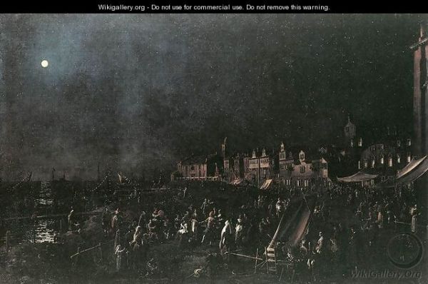
“La Vigilia di Santa Marta” (The Eve of Santa Marta) by Canaletto. c. 1760. (Wikigallery.org). This view shows the Zattere, with the church of Santa Marta the last building in the distance. I realize that they did not have stadium lighting back then, but I’d have hoped to see more of the famous illuminated boats. I think he was paying too much attention to the geometry of the painting and not enough attention to what was really going on. Or maybe that’s just my way of saying “I wish I’d been there.”
July 29, as all the world knows, is the feast day of Santa Marta. Or in any case, now the world knows.
She is essentially forgotten here; her church has been deconsecrated, swallowed and partially digested by the Maritime Zone, and her celebration — once one of the greatest of the many great festivals here — is gone forever. Only a painting by Canaletto brings us the tiniest (and darkest) glimpse of what was once a very big night in Venice. Her name today is used mainly to refer to the adjacent neighborhood.
The reason I didn’t get this post finished by July 29 is because I got lost reading assorted accounts, some of them first-hand, about this uber-fest. It didn’t take me long to conclude that the fabled feast of the Redentore, which has remained a very big deal, was really nothing so remarkable compared to Santa Marta’s. The Redentore had fireworks, it’s true, but Marta had fresh sole.
Fish was an excuse for a colossal boating party? Why not? The Venetian civil and religious calendar was bursting with events of every type and voltage. A very short list would note the festivals of Santa Maria della Carita’, Palm Sunday, S. Stefano, “Fat Thursday,” May 1, or the Doge’s Visit to the Monastery of the Virgins, S. Isidoro, the taking of Constantinople (1204), the regaining of Candia (1204), S. John the Baptist “Beheaded,” Sunday after Ascension Day, the victory over Padua (1214), the defense of Scutari (1479), the victory of Lepanto (1571), S. Rocco, Corpus Domini, the victory of the Dardanelles (1656), and the conquest of the Morea (1687). These are just a few of the major events; the Venetians also commemorated defeats. There was something going on almost every day.
But there was always room for more, and although Santa Marta couldn’t claim to have sponsored any particular victory, discovery, or other noteworthy occurrence, her feast day conveniently fell in the period when the weather was suffocatingly hot, and the sole were in season. Plus, her church was located on a little lobe of land facing lots of water, and there was a beach. All this says “Put on your red dress, baby, ’cause we goin’ out tonight” to me.
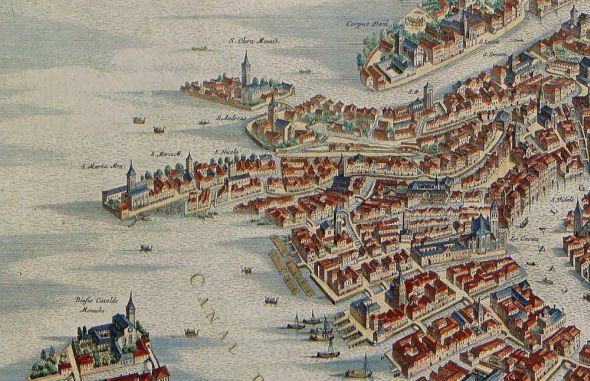
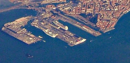
Joan Blaue’s map of the late 1600’s shows the peninsula crowned by the church of Santa Marta, but I don’t see a beach. On the other hand, I do see rows of rafts formed of logs — “zattere” — in front of their eponymous stretch of waterfront. Nice.On Ludovico Ughi’s 1729 map, “Pictorial Representation of the Illustrious City of Venice Dedicated to the Reign of the Most Serene Dominion of Venice,” we see something like beach surrounding Santa Marta’s headland. To each cartographer his own.And this is how how that little lobe of land looks today. The big docks at Tronchetto were built in two stages in the 20th century, and Santa Marta (lower right corner of land) has become an afterthought. (www.panoramio.com)
The basic components were: Everybody in Venice, either on land or on the water, regardless of social station or disposable income; every boat in Venice — so many boats you could hardly see the water, festooned with illuminated balloons and carrying improvised little arbors formed by frondy branches; music, song and dance, and lots and lots of fresh sole.
A “genteel” sole, who was more the star of the evening than Santa Marta herself.
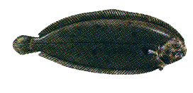
July is the season for sfogi zentili, or Solea vulgaris, and while the Venetians could bring their own vittles, plenty of them also bought the fish which had just been saute’d, either on the beach or on the street by enterprising entrepreneurs. If you were really in luck, there would be moonlight, too.
The best and most famous chronicler of this party was Giustina Renier Michiel, who was born in 1755 and belonged to several patrician Venetian families. She spent 20 years researching her six-volume work, Origine delle Feste Veneziane (1830), but the fact that she had personal memories of many of these events makes her books exceptional.
I started to translate what she wrote about the feast of Santa Marta, but she went on so long, and her style sounded so curious in English, that I became tired and discontented. So I’m going to give some bits and summarize the rest. Anyway, it’s clear that the event was so phenomenal that even people who saw it finally gave up trying to describe it adequately or coherently.
Here is her version of how the festa was born:
“In the old days many groups went out in certain boats to fish for sole, the best fish that one eats in July. (Lino concurs with date and description.)
“And in the evening they would go back to the beach by the church of Santa Marta and feast on the fish, enjoying the cool air that restored their depleted strength after the labor of fishing, as well as the heat of the season.
“Later on, as the population became richer, and softness set in, the work of fishing was left to the poor people, who had to do it in order to live, and what used to be a fatiguing labor changed into a singular entertainment.”
My version: It didn’t take long for everybody else in Venice to say “A cookout on the beach? We’re on our way.” Everybody started making Santa Marta’s Eve a great reason to head for her neighborhood and eat fish, garnished and enlivened by the classic saor sauce of sweet-sour onions. It was like a gigantic clambake, a barbecue, a luau, for thousands and thousands of people.
Obviously the beach was too small for everybody, so the boats made themselves at home on the Giudecca Canal, “whose waters could only be seen in flashes, and almost seemed to be strips of fire, agitated by the oars of so many boats that covered the water and which doubled the effect of the lights which were on the boats.”
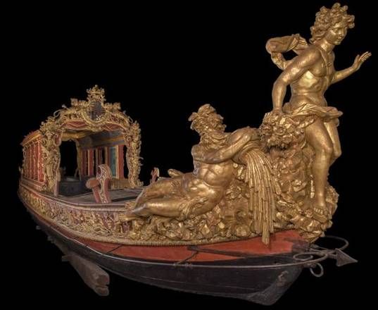
The “Bucintoro dei Savoia,”also called the “Bucintoro del Po,” is the only surviving example of a Venetian peota of the 18th century. It was built in 1730 by a squero on Burano for Carlo Emmanuele III di Savoia and is now the property of the Civic Museums of Torino. Most noble families had one, and they were just the thing for big events such as the Regata Storica, processions honoring doges and kings, and alfresco picnics featuring a big fish fry.
The patricians came out on their fabulously ornate peote, and often carrying musicians who sang and played wind instruments. There were scores of the classic fishing boat called a tartana, draped with variously-colored balloons and loaded with laughing families and friends. There were artisans in their battellos, and hundreds of light little gondolas, and plenty of gondolas da fresco, and there were even the burchielle, the heavy cargo boats that carried sand and lumber. If it could float, it joined the vast confusion of boats being rowed languidly in every direction, or tied up along the Zattere where there was just as much happy turmoil ashore.
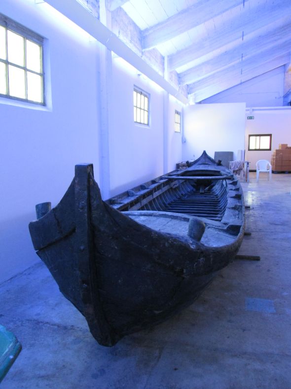
Or, if you were a fisherman, you might come out in an equally impressive (in its way) boat — a caorlina da seragia. Only a few still exist, and this very old craft has retained its original pitch waterproofing. You could fit several families, aristocratic or otherwise, into this monster.Or if all you had was a little s’ciopon, you’d have bedecked it too, and come out with the food and family.
The Gazzetta Urbana of 1787: “Along this riva, called the Zattere, the cafe’s and bars are crammed to overflowing with people. There are tables set up outside their doors, and everything is so lit up that it seems to be daytime.
“The passage (of people) in all the streets leading to Santa Marta was dense and continuous, and the splendid gathering at the Caffe of San Basegio, at the head of the Zattere, formed a separate spectacle, in which our Adriatic beauties, wearing modern shimmering caps in the Greek style, ornamented with plumes, inflamed with their glances the hearts of the young men who, like butterflies, always flutter around the flare of a woman’s beauty.”
Also amid the throng were little ambulatory kitchens — a man with a basket of sole would put two stones on the ground, then lay two bunches of sticks crosswise on them, light a little charcoal under them, pour some oil in a pan, and stand there bawling for business. He kept a container of saor ready to put on the fish.
Renier Michiel: “The entire length of this district was full of a grand concourse of people, moving toward the piazza of Santa Marta which was the best vantage point to enjoy the spectacle. On the piazza there were more food vendors, some of them selling roast chicken. There is a racket of cups, plates, the yells of the vendors, the music from the boats on the water. Every house is transformed into a sort of tavern where people eat and drink, and there was perfect joy and harmony.”
“Perfect joy and harmony”? How can this be (apart from the fact that she was looking back on it, years later, when the festival was gone forever)?
I think it’s because Santa Marta was secretly taking care of people. She is the patroness of cooks, butlers, laundry-workers, servants, housewives, and waiters. Though I suppose you could just say “housewives” and leave it at that.
Because as Santa Marta, and 99 percent of women on earth, can attest, while some people at a party are laughing and scarfing the canapes and playing with the dog and singing comic songs and reveling in industrial-size helpings of joy and harmony, there’s at least one person somewhere in the background doing everything to make it seem as if there is absolutely nothing that needs to be done.
And I have no doubt that when the boats went home at dawn on July 29, there was somebody who had to put the boat away and swab the bilge and pick up every single fishbone, as well as deal with the dishes and the wine- and saor-stained clothes. Behind every great saint is somebody with a bucket and mop, I say.
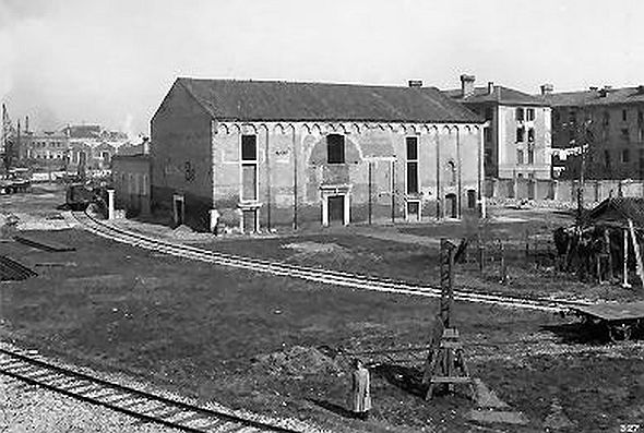
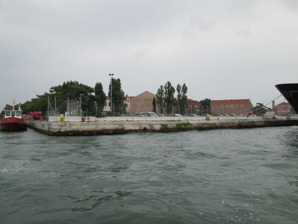
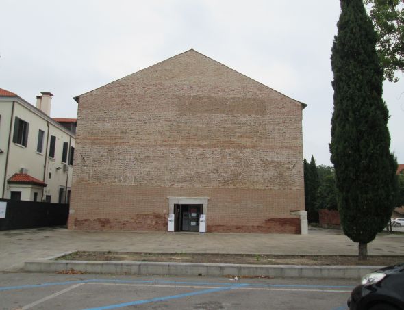
You can barely make out the “Punta di Santa Marta” from the roof of the Molino Stucky Hilton.The church of Santa Marta in 1934 was only slightly in the way of progress. Trains came down onto the waterfront to deliver or collect cargo to the ships in the maritime zone. No more beach.There’s still a church in there somewhere behind the parking lot. Ex-church, that is, restored and now used as an exhibition space. Nice that it’s not falling to ruin, but any possible trace of character or history has been thoroughly expunged.I realize that it wasn’t ever the most heavily decorated building in Venice, but they seem to have gone to the opposite extreme here. Seen from this angle, it could be a Potemkin church.To review in closing: This entire area of water was completely covered with illuminated boats full of people singing and eating and laughing and being happy. And I think it’s safe to say that most of them were not tourists. That’s something else to recall occasionally — that Venice had an amazing life that had nothing to do with tourism. Seem strange? They’d think we’re even stranger.
We left our story — “The Interminable Quest for the True Provenance of the Viale Garibaldi, as Recounted by People Living and Dead (I suppose that should be “living or dead”), with Illustrations and Funny Spelling” — at an uncomfortable point between things I knew and things I only thought I knew.
Several readers have since written me giving me more information and opinions than I’d expected (that’s not saying much, considering that I expected none). My ensuing labors to sift, evaluate, cross-check, confirm, and make at least one educated guess have led me to the last thing I’m going to say about viale Garibaldi. Not that there couldn’t be more, and there probably is more, but my interest is dimming and I’d bet yours is too.
The story so far:
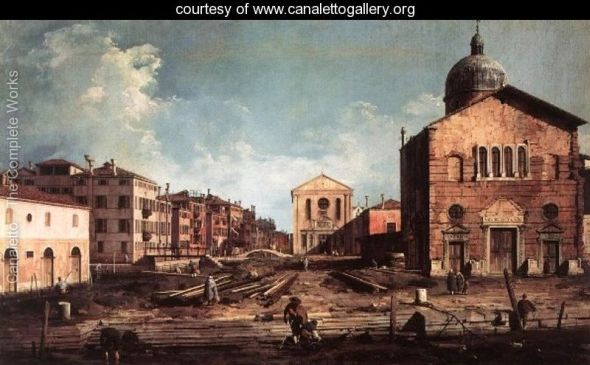
A view of the church of San Giuseppe di Castello, by Antonio Canaletto. The church in the foreground was torn down , houses built in its place, and a row of trees was planted in front of the houses.
Canaletto painted a picture showing a section of Castello as it no longer appears. I deduced from the painting that the vantage point from which he painted it was a canal which was later filled in to make the present gravel walkway lined by lime trees named the viale Garibaldi.
Please note that much confusion can be avoided by remembering that via Garibaldi and viale Garibaldi are not the same thing. “Viale” is a word which, among various translations, means “tree-lined avenue.”
A reader questioned my original assertion and its various geographical and geometrical elements, and proposed that the water seen in the painting was instead a glimpse of the Bacino of San Marco, where its rippling wavelets caressed the smooth stone surface of a working riva (fondamenta). He proposed it in less overwrought terms.
I found a map by Joan Blaue (date unknown by me, except that it was made in the 1600’s) which shows that there was indeed a riva in that place, leading down into the waters of the Bacino of San Marco, and not at all the canal I had imagined.
In brief, I was wrong and he was right.
A cropped section of the view shows the location as it was just before Canaletto’s day. Although the proportions seem to be a little hinky, there is no denying that the churches painted by Canaletto were facing the Bacino of San Marco. He doesn’t show as clearly as Ughi does (below) the street that became the viale, but I see that it’s there.
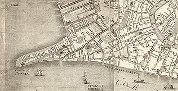
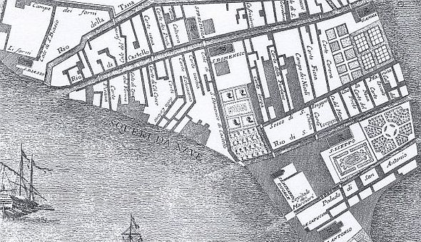
Another reader then wrote with more information and opinions, and attached a detail from another map, which I am showing here. It was made by Ludovico Ughi in 1729 — slightly after Canaletto’s time, but probably not long enough to matter to our story.
As you see, Ughi identifies a clearly non-canal strip of territory as “Cale di S. Domenico di Castello.” If it was a calle (street) in 1729, I’m going to assume it was a calle in 16-whatever-it-was when Canaletto painted his picture.
Or maybe you can’t see it. It’s the broad line that begins in the “crook” of the waterfront and goes north till it hits the “rio di Castello,” the canal which became via Garibaldi.
Detail of the area in question from Ludovico Ughi’s map of 1729. The “Cale di S. Domenico di Castello” is located exactly where viale Garibaldi is today.
Conclusion: Making assumptions can be dangerous, as my original post demonstrated, but I think the evidence is now reasonably clear that the present viale Garibaldi was not a canal in the 17th century.
That’s really all I’m interested in saying about this. Whatever it was, or wasn’t, or dreamed of being, but couldn’t, or might have been if Napoleon or Nikola Tesla or Fannie Bloomfield Zeisler hadn’t intervened, is a story I’m not going to be pursuing anymore.
I’m all for knowledge — the more, the better, even as it gets broken and reassembled in ever-tinier pieces and shapes. But unless somebody can convince me that Jimmy Hoffa is buried under the third bench on the right, I’m going to leave this subject and go on to something else. Perhaps something more interesting, maybe even more important. But at least it won’t be about the viale Garibaldi.
Contains information related to marketing campaigns of the user. These are shared with Google AdWords / Google Ads when the Google Ads and Google Analytics accounts are linked together.
90 days
__utma
ID used to identify users and sessions
2 years after last activity
__utmt
Used to monitor number of Google Analytics server requests
10 minutes
__utmb
Used to distinguish new sessions and visits. This cookie is set when the GA.js javascript library is loaded and there is no existing __utmb cookie. The cookie is updated every time data is sent to the Google Analytics server.
30 minutes after last activity
__utmc
Used only with old Urchin versions of Google Analytics and not with GA.js. Was used to distinguish between new sessions and visits at the end of a session.
End of session (browser)
__utmz
Contains information about the traffic source or campaign that directed user to the website. The cookie is set when the GA.js javascript is loaded and updated when data is sent to the Google Anaytics server
6 months after last activity
__utmv
Contains custom information set by the web developer via the _setCustomVar method in Google Analytics. This cookie is updated every time new data is sent to the Google Analytics server.
2 years after last activity
__utmx
Used to determine whether a user is included in an A / B or Multivariate test.
18 months
_ga
ID used to identify users
2 years
_gali
Used by Google Analytics to determine which links on a page are being clicked
30 seconds
_ga_
ID used to identify users
2 years
_gid
ID used to identify users for 24 hours after last activity
24 hours
_gat
Used to monitor number of Google Analytics server requests when using Google Tag Manager