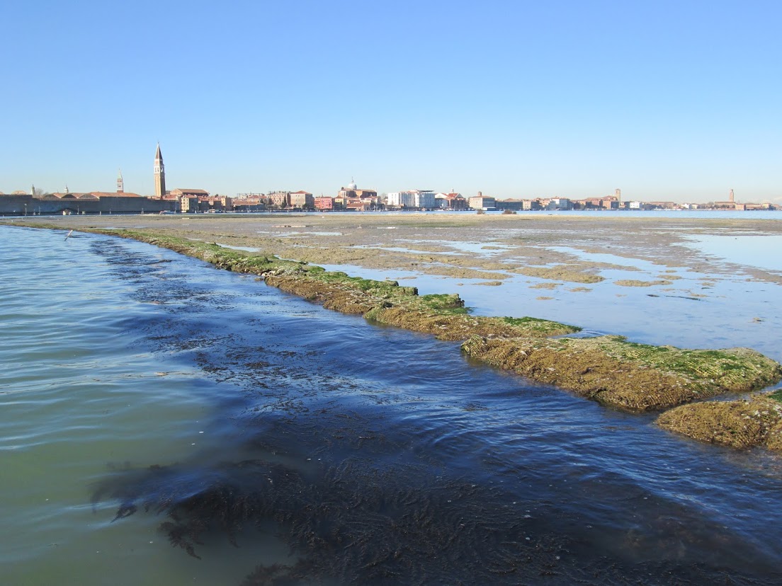
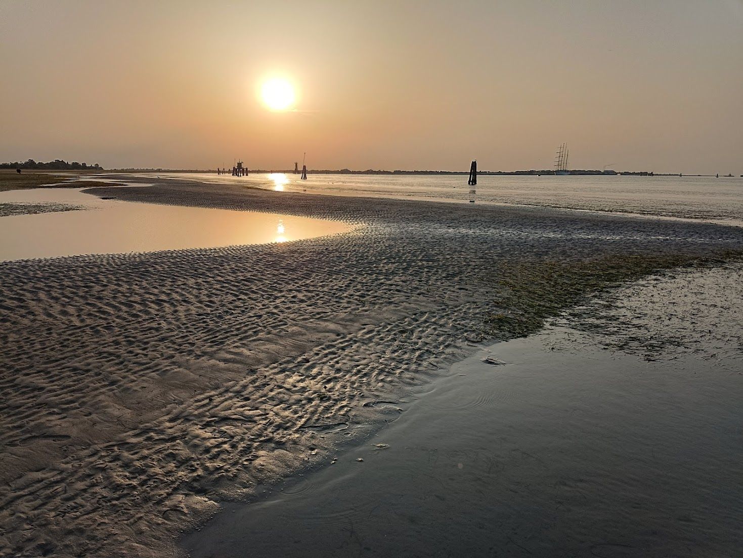
In the canals, too much mud can be a problem, but one doesn’t see it until the extreme low tides of mid-winter. When anyone asks me how deep are the canals, I usually ask “You mean at high tide? Or low tide?” The height of the water changes, but over time so does the height of the mud.
You could call it the lagoon’s base layer. There are places where there’s too much mud, mainly in the canals; it accumulates and creates problems for boats when the tide is low and, equally important, problems for buildings whose drains it has blocked, and so we have to take it away.
But there is an equal and opposite problem of there not being enough mud in places around the lagoon, where dredging has been heavy or, more frequently, where the motondoso (waves from motorboats) has loosened the soil, and the tide and waves have washed it out to sea. Waves that demolish the wetland marshes (barene) or, on the other hand, fill up channels, have been known for years to be wrecking the lagoon’s wrinkly underwater shape, smoothing it out and slowly turning it into a sort of bay of the sea. Bays of the sea are an entirely different ecosystem from lagoons, but no matter! Motors are indispensable for keeping the city going, and the lagoon is just going to have to suck up (so to speak) the consequences.
At water-level you may notice only water, but the lagoon is full of mud.
The 17th-century Venetians knew the lagoon dynamics intimately. Their survival depended on it. Fears of the lagoon silting up from the several rivers that flowed into it led them to an epic undertaking: From 1600-1604 they cut the river Po to divert it southward into the Adriatic.
In 1993 it was decided to redistribute the quantities of mud in the city and lagoon: Simple, logical, effective, positive. Dredging proceeded and the mud was deposited in various locations where it was useful, or at least not problematic. In fact, moving mud around is far from a recent phenomenon — it’s been done many times over the centuries resulting in consolidations, expansions, and entire new islands. This assortment of maps showing the Morphological Evolution of the Lagoon of Venice from the XVI Century till today is very interesting. In the 20th century Tronchetto and Sacca Sessola, to name only two, rose from the lagoon bottom created with dredgings.
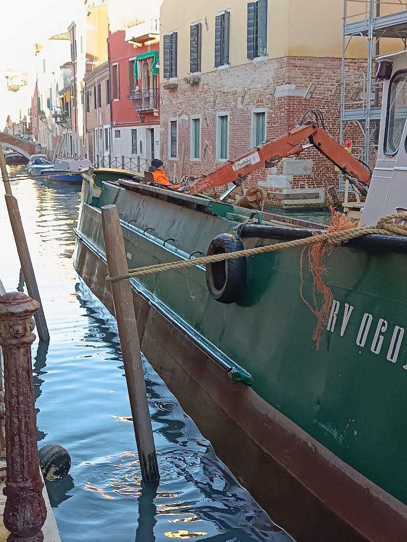
And so, in the fullness of time, the dredges were at work outside our door in 2021, and they were at it again just two months ago. All seemed to be going well, but suddenly we read that things have taken an unexpected turn. The mud is unusable!
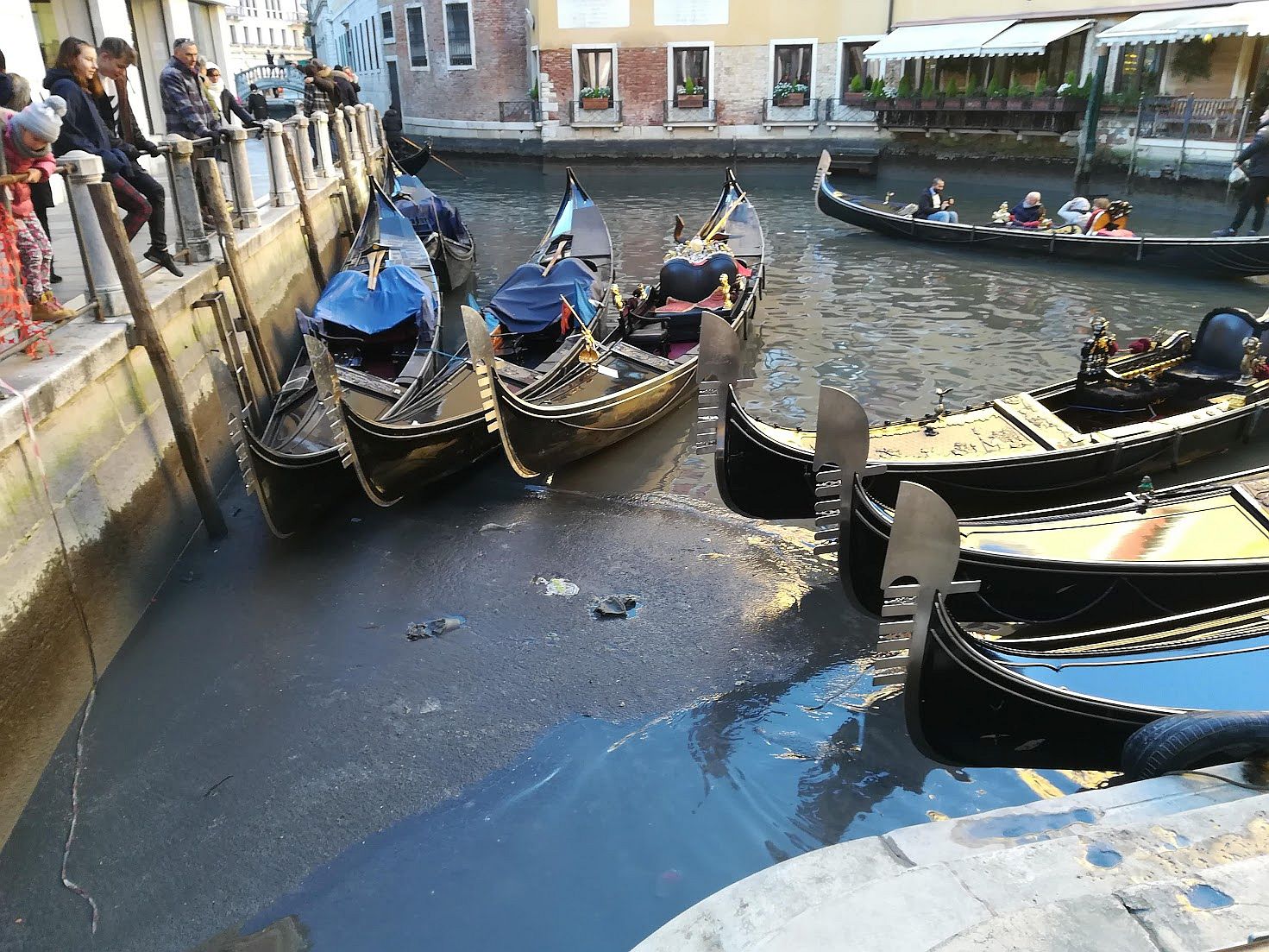
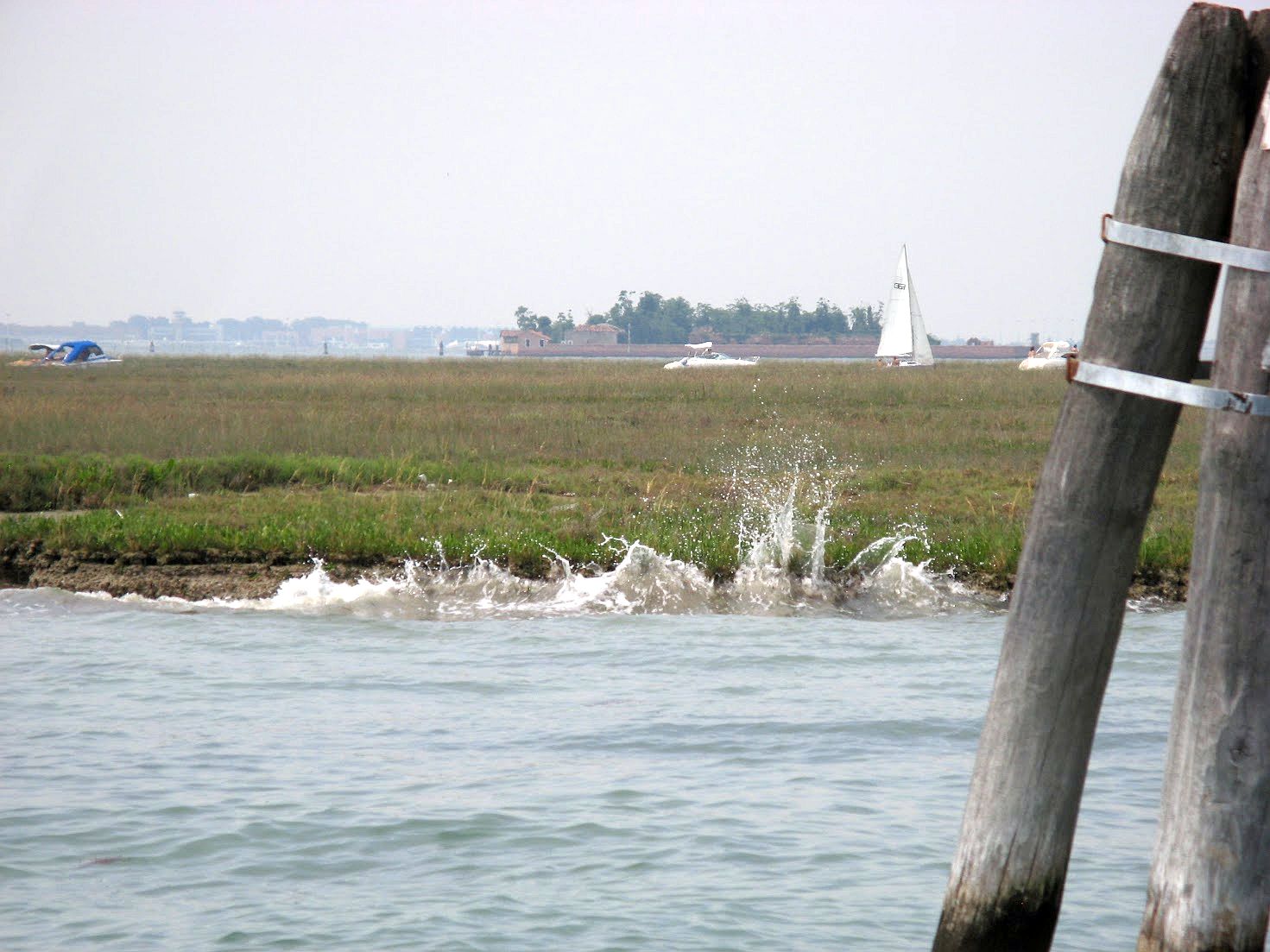
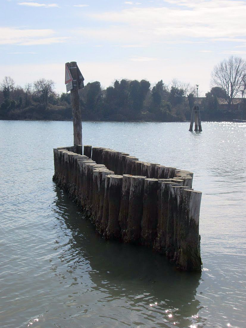
The dredger the first day of work thought it was a good idea to tie his behemoth to one of our little pilings to resist the weight of the mud he’s pulling up. He was wrong. But you can appreciate something about the mud here: It’s tenacious. Once it grabs onto something, it really doesn’t intend to let go. This went on for hours, the modest pole yanked sideways, as you can see; it simply couldn’t be dislodged, although it’s now a bit shaky. The next day he moored the monster to the metal ring on the street, and we’re trying to help our piling begin to trust people again.
The headlines have been blunt: “Unusable muds, the lagoon in crisis, the dredging has been stopped in the lagoon.” “The new Protocollo of 2023 for the sediments dug in the canals doesn’t work anymore because the parameters of ecotoxicity are too rigid.” “First they were considered clean and good for reconstructing the barene. But no more: Now there’s a risk of blocking also the dredging of the most polluted.”
This problem has come up literally in mid-dredge. It’s a little awkward to discover that the Protocollo of 2023 is invalid when the barges are full of mud, so now what? Is there a Plan B? “Strictly speaking, we don’t have one,” to quote CIA operative Gust Avrokotos in the film “Charlie Wilson’s War.” “But we’re working on it.”
So what changed all of a sudden? It’s that, as the headline noted, the standards are suddenly stricter as to what mud is classified as “ecotoxic” (either biological or chemical) and therefore where it can be dumped. (Don’t write in, I know that everything is chemical, looking at the universe. We’re roughly distinguishing here between chromium and E. coli.)
Nobody’s surprised to hear that there are toxic substances in the lagoon — just look at the Industrial Zone shoreline and draw your own conclusions. A few years ago the University of Padova and Ca’ Foscari in Venice studied some mollusks taken from the channel bordering the mainland. Researchers found that the bivalves contained a quantity of poisonous substances 120 times higher than in the rest of the lagoon.
So here we are. Where will the mud go?
Men used to do this with shovels. Not underwater, of course.
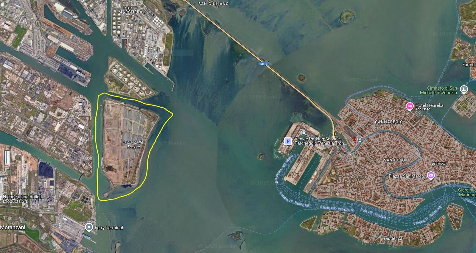
All muds are not created equal. Category A, the cleanest kind, is safe to put under the water, so it can be used “nourish” the shrinking barene. Other muds, the more toxic Category B and C, can’t be put back into the lagoon, no matter how worthy the reasons, and have to be banished to the Tresse island. And God forbid all these muds should become mixed together. Burning the mud is an interesting proposal, but it’s hard to agree on where to put the ash.
Also, the Tresse at the moment is running out of space. There have already been discussions about enlarging it, but quantity and quality, as often happens, are in conflict. Decisions lag. Bureaucratic, legal, logistical issues keep bumping into each other. Cost must be in there too, somewhere. The Morphological Plan of the lagoon was shot down in 2022 and nothing has been heard of it since.
The Isola delle Tresse began in the 1930’s as Storage Tanks island, and was expanded in 1993 with a million cubic meters of mud and other material dredged for the benefit of the Port of Venice. This raised the island by nine meters (30 feet) and doubled it in size. Now it has been proposed to deposit as much as an additional four million cubic meters of mud, which would raise the island as high as 13 meters (43 feet). May I take just a moment to recall that when UNESCO designated Venice as a World Heritage Site in 1987 it also included the lagoon? Toxic mud doesn’t sound very World Heritage Sitey.
So, back to the dredging at hand: After weeks of hardy gouging and hauling, the mud’s permission to land, so to speak, has been revoked. The Department of You Should Have Seen This Coming isn’t answering its phone.
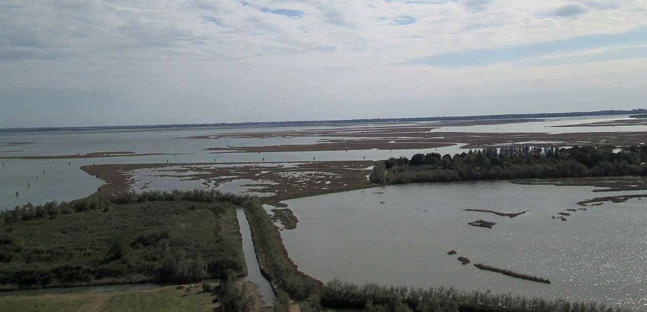
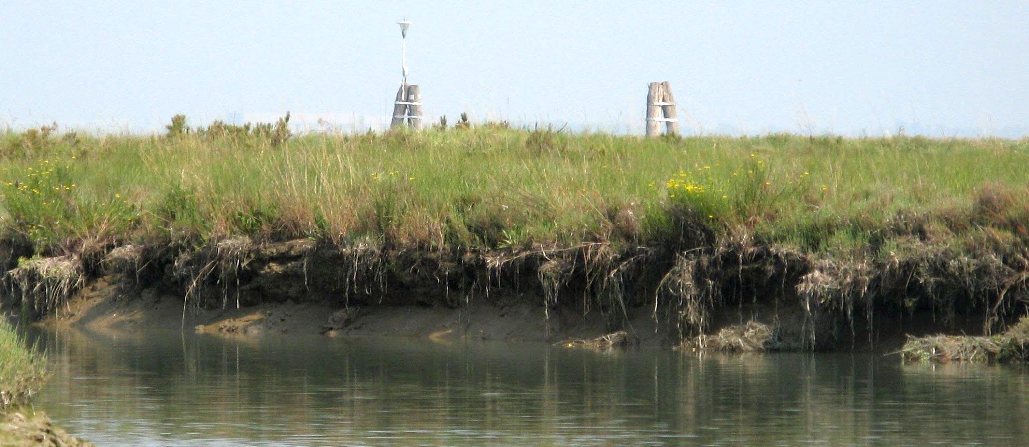
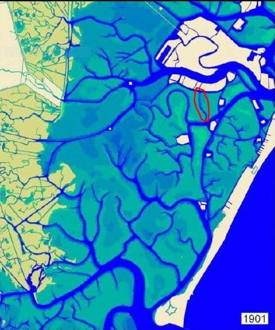
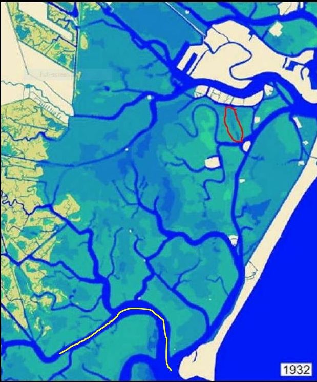
The barene (semi-solid mud) are beautiful and crucial to the whole ecosystem. But motondoso, or waves caused by the anarchy of motorboats, slices away at their soft soil. This goes on all year long, but especially in the summer. Note the distance between the wooden piling and the islet. They used to be much closer together. Shrinking barene aren’t good for the health of the lagoon as a whole.Of course the plant roots help stabilize the soil, but they only go down so far. Soon the upper layer will collapse and slide into the water, filling up the channel. We need the barene and we also need the channels, but they do not play well together. Eventually there will be too much mud in the channel, and not enough island, and dredging will be called for. And perhaps expansion afterward. Not literally inconceivable.To resist the waves gnawing at the barene, various defenses have been tried. Above is somebody’s idea of a breakwater. The barena is clearly not reacting as the planners intended. You can see here why it was hoped that the latest batches of dredged mud could enlarge shrinking bits of land, because more and/or larger barene would be a great thing for the ecosystem. Even if you don’t care about the ecosystem — I don’t judge — more barene would serve as barriers to slow the incoming tide, the way they always did before motondoso began to tear them apart.This construction is not destined to last long; the team behind this project seems not to have observed what happens to wooden pilings in the water.The lagoon loses 600,000 cubic meters of sediments every year, leaving an increasing wasteland behind. You can easily see the difference between the lagoon north of Malamocco (divided by the Canale dei Petroli, about which more below), and the southern lagoon. If too much mud in one place is a problem, too little mud in another isn’t any better. Fewer barene and fewer channels mean the water can rampage around and carry even more mud away with the tide, or deposit it unhelpfully elsewhere.1901. We see lots of squiggly channels back then (which, like the barene, slowed down the tide, and the dislodging of sediments). You also see that the shoreline was squishier and more ragged, providing more space for the water to come and go, moving more slowly in the process. But too many channels were doomed, like the little one circled in red above.1932. Look at the little channel (ghebo, in Venetian) circled in red again. You see that natural processes have caused it to begin to fill in, but it was still in good shape at least ten years later because Lino remembers it well. His father would take him out fishing in their little boat and they rowed along this canal on their way to the best spot to “dig” for canestrelli, or little lagoon scallops (Aequipecten opercularis). Note: The different colors indicate varying depths of the water. You’ll see that change over the decades too.
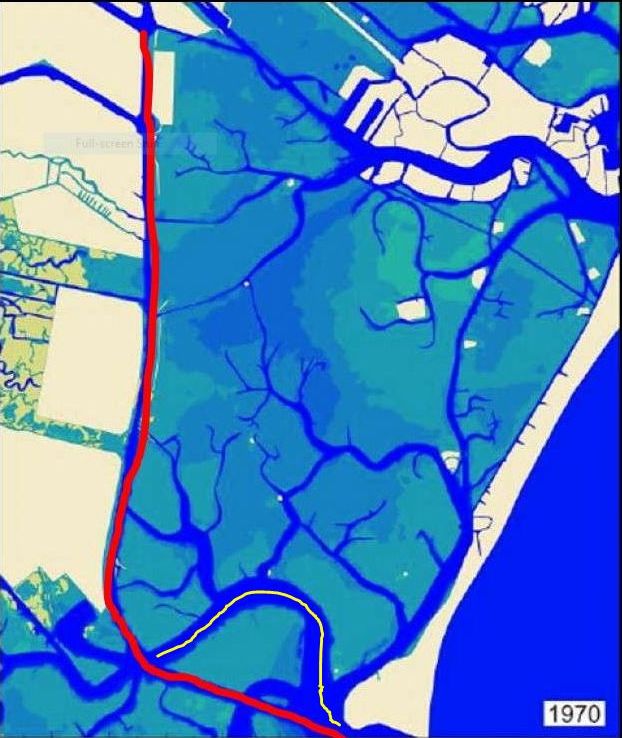
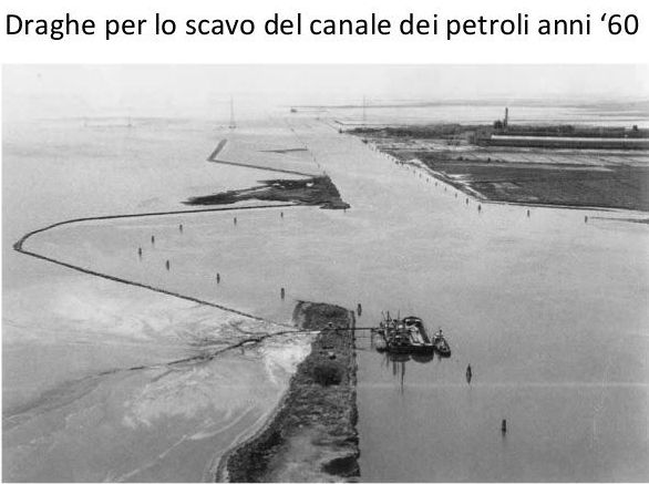
In the Thirties the Industrial Zone was being built; for Venice’s post-war economy it seemed like the greatest plan ever, and in many ways it was. In their great days (now past), the chemical refineries here were the largest in Italy. Oil and chemical industries require raw materials, and those require ships, and ships require reliable channels for passage. That broad, curving channel marked in yellow on the map above that enters the lagoon from Malamocco does not look like anything a big ship would want to navigate, and of course ships also need a waterway to reach the mainland port area. And so the Canale dei Petroli (“petroleum canal,” in honor of the expected tankers) was planned.
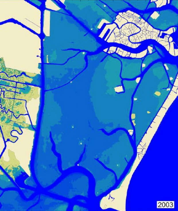
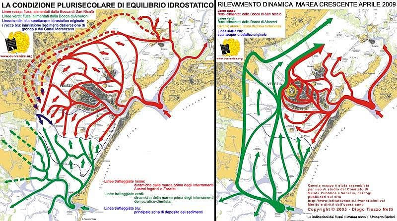
1970. The triumph of the shipping. The broad, curvy yellow channel (which also slowed the force of the tide) was bypassed in 1964-1968 by the digging of the channel that is straight as an airport runway: The Canale dei Petroli. The resulting tons of mud went to the shoreline, reshaping it by the formation of three longish islands (generically called casse dicolmata) that were created along the flank of the mainland. They were intended as the land for the Third Industrial Zone, which was never built. Left to their own devices, they’ve become a sort of oasis, especially for birds.Dredging the Canale dei Petroli created a channel 18 meters (60 feet) deep, 15 km (9 miles) long and 200 meters (656 feet) wide. If you had wanted to suck the sediments out of the lagoon, you could hardly have done better. But the wakes of the cargo ships also stir up the sediments and they don’t all reach the sea. Result: More dredging is needed periodically as the channel proceeds to silt up. Further result: The tide entered faster and with more force than ever before, and before you could say “Worst flood in Venice’s history, November 4, 1966” the city went under. Venetians weren’t slow to see a connection between the canal and the flood, but what was done was done.And this is more or less the situation today.Moving mud means moving water. These maps were made in 2009, so the situation may well have changed yet again since then. Looking at you, effects of MOSE. (On the right panel: This map was assembled for study use of the Committee of Public Health of Venice, from the pages published on the site https://www.istitutoveneto.it/flex/cm/pages/ServeBLOB.php/L/IT/IDPagina/1. Credit and rights to this work belong to Diego Tiozzo Netti. The indications of the tidal flows are by Umberto Sartori.)
We’re looking at tide patterns, otherwise known as the hydrostatic equilibrium of the tides in the lagoon over many centuries.
LEFT PANEL: The solid red lines show the tidal pathway from the inlet at San Nicolo’. The solid green is the water entering from Malamocco (Alberoni). The thin blue line across the center of the lagoon emphasizes what we can see where the arrows meet, the point where the two incoming tides form the spartiacque, or “division of the waters.” The dotted red lines show tidal flow before the landfills created by the Austro-Hungarians (who left in 1866) and Fascists (1922-1943). The dotted green lines show the tide before the landfills made by the post-war “democratic-clientele governments.” The dotted dark-blue lines are the principal zones of sediment deposits, which makes sense considering the movement of the tides.
RIGHT PANEL: The pattern of the rising tide in 2009. The solid red line shows the pattern of the tide entering the lagoon from the inlet at San Nicolo’. The solid green line shows the tide entering from Malamocco (and, obviously, along the track of the Canale dei Petroli.) This graphic shows the effect of losing the mudbanks, natural channels and barene, smoothing out the lagoon bottom that used to be naturally uneven and knobbly.
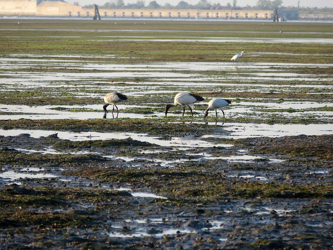
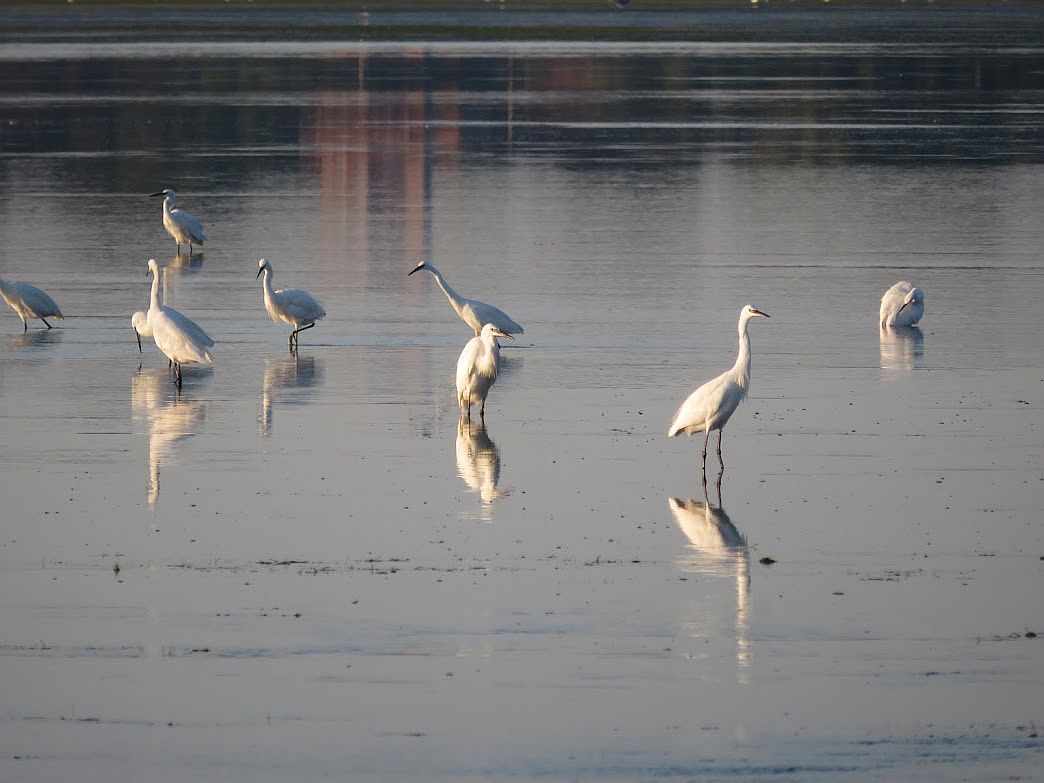
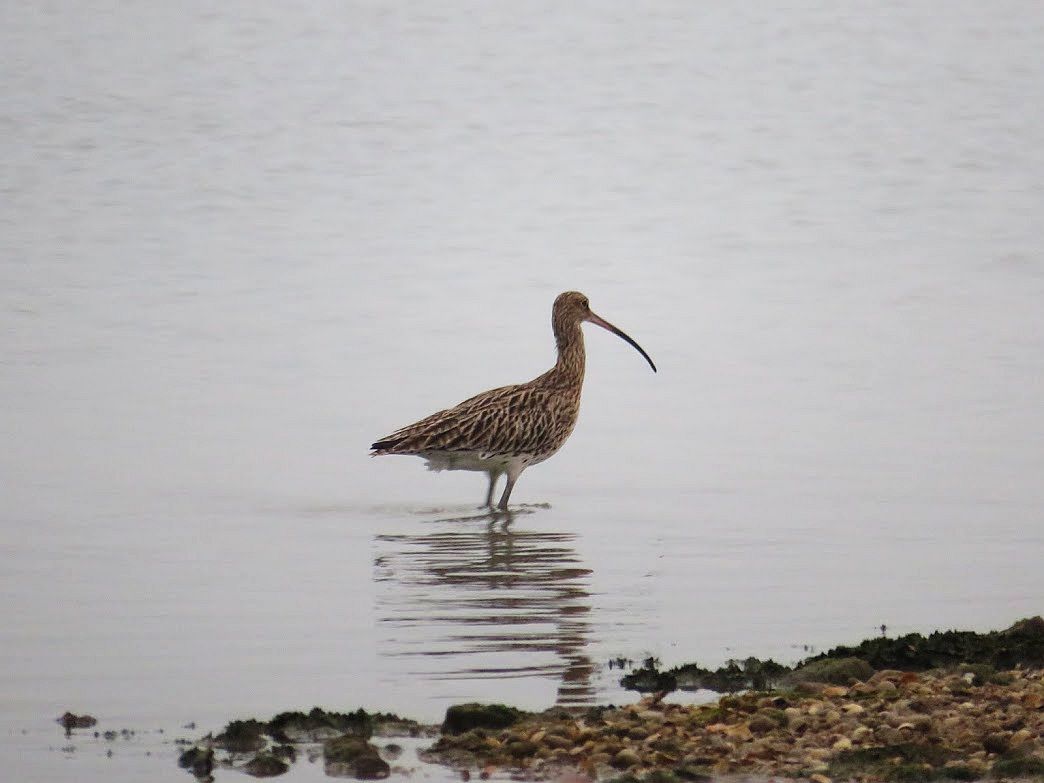
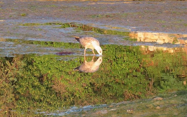
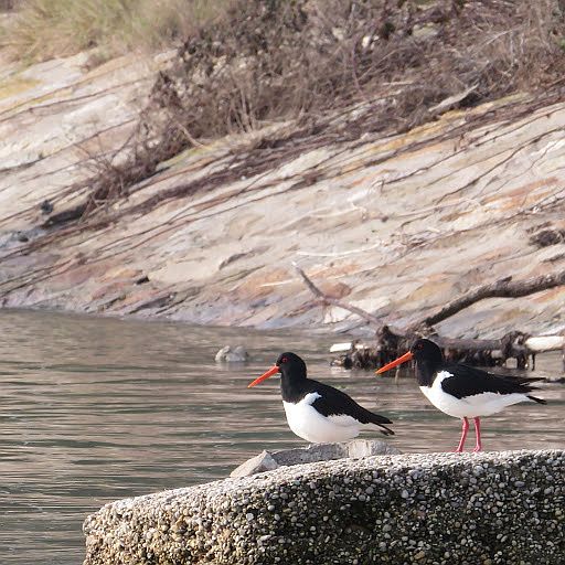
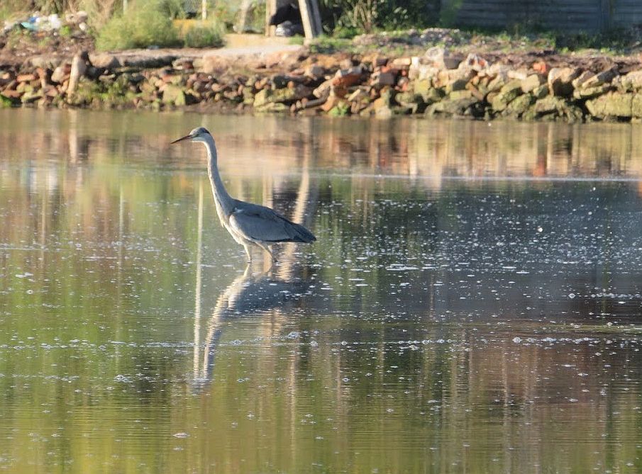
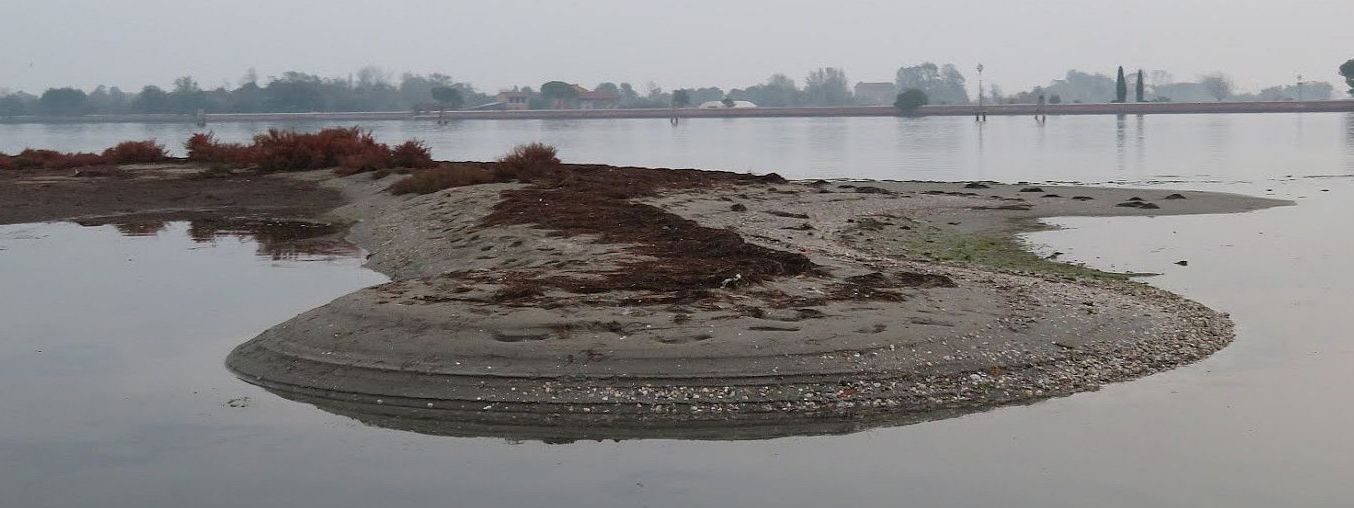
I think the tides and the mud matter more to many other creatures than they do to mere humans. This barena that was built next to the Certosa island is a haven for flamingoes, Eurasian oystercatchers, egrets, herons, common shelducks, and the now-ubiquitous sacred ibis. And undoubtedly more that I haven’t discovered yet.The ibis (Threskiornis aethiopicus) love the mud.Snowy egrets (Egretta thula) don’t particularly care about mud, per se, but they like the easy fishing when the water is shallow.Curlews (Numenius americanis) absolutely love the mud, digging up worms and other little submerged treats.The plover (Pluvialis squatarola) is another huge fan of mud.The oystercatcher (Haematopus ostralegus) is really beautiful, unless you’re an oyster, obviously. They also wade around looking for mussels and earthworms.The grey heron (Ardea cinerea) is the apex wader. Evidently he’ll eat almost anything.Here the lagoon bottom is fairly firm when it’s exposed at low tide, but if you walk into the water you will sink into squishy mud up to your ankles. Pause to admire the tracks of the birds who have traversed this territory, snacking to their heart’s content.
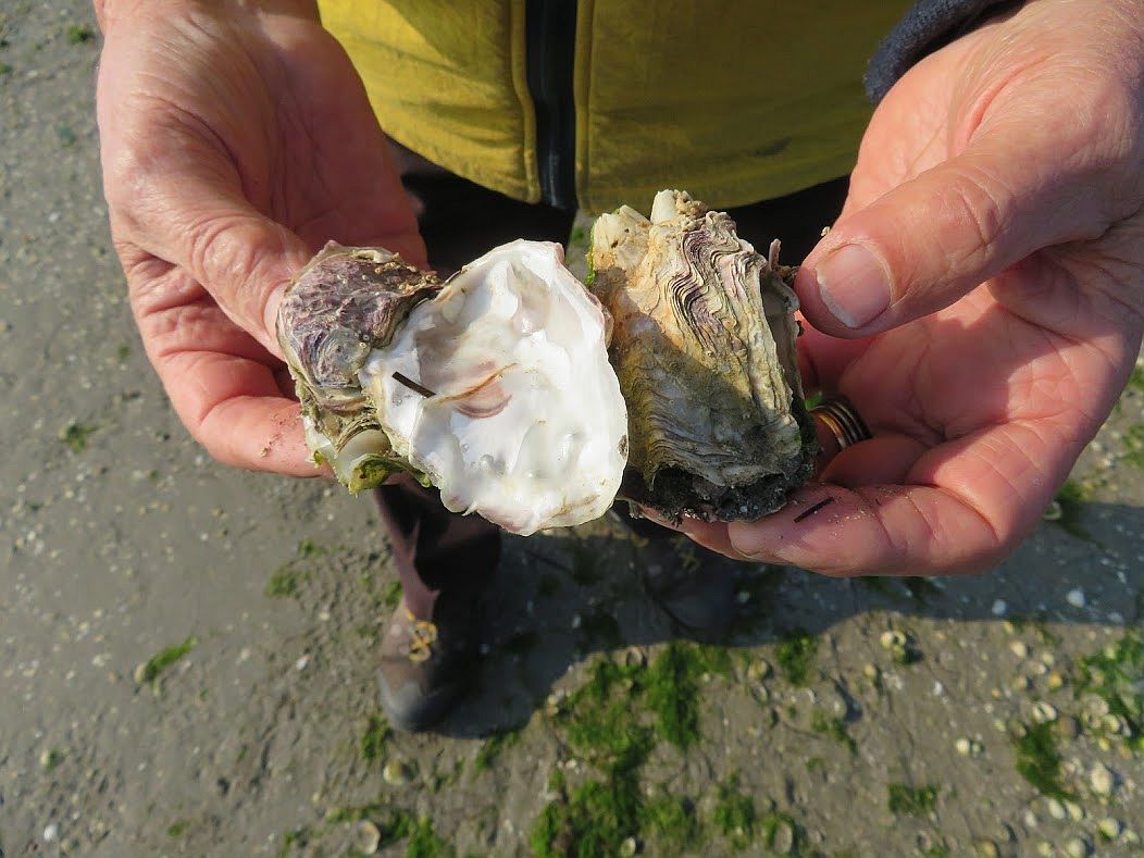
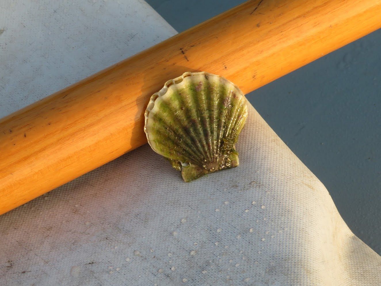
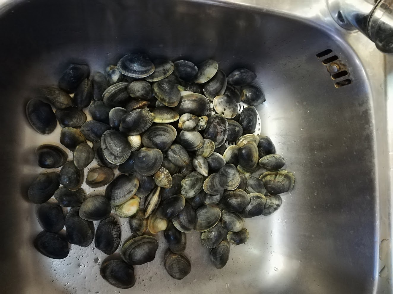
The important thing is that the lagoon bottom isn’t perfectly flat.This is evidently the perfect place for a feast. The shore is littered with clam and oyster shells, the casings of creatures that need the mud to live.The mud doesn’t just feed the birds. There are indeed oysters in the lagoon and they are delectable. Lino spent one Christmas Eve afternoon out in the lagoon and brought home a batch of these for our dinner. These three clutched together, though, seem to have formed a sort of Wagnerian pact or something.We sometimes find scallops, even though they’re not as plentiful as when Lino was a boy and would go home with a bucketful.That was a good day out — lots of different types of clams (and this isn’t all of them, by any means). They may be pondering how unmuddy the world has suddenly become.Regard the mud. The waves from some passing boats clearly show that the mudbank is just below the surface.You see water, I see mud. The surface is smoother where the water is shallower as the tide rises or falls. If you’re out rowing and you see this, you have only yourself to blame if you run aground. You were warned.
If you want a lagoon, you have to want mud. Otherwise you might just as well look at your bathtub.
So the Costa Concordia ran aground (January 13) and the administration here instantly went into several varieties of fits to show how eager it was to ensure that no such catastrophe could ever be inflicted on the most-beautiful-city-in-the-world by one of these leviathans, whose number is increasing at a Biblical rate.
Passengers see a ship. The anti-ship cadre sees a potential disaster. The city government sees a floating Brink's truck loaded with money, without which Venice can no longer survive. You decide.
Mission: Banish the Big Ships from the Bacino of San Marco where they might well run into a section of historic and irreplaceable real estate. I haven’t seen any calculations on the odds of this risk, but they may be similar to the odds of winning the lottery.
Lots of people who buy a lottery ticket think/hope that the probability of winning could be pretty good. In the same way, lots of people who see the big ships passing think/fear that the probability of a huge catastrophe could be pretty good. The distance between “could” and “might” is hard to measure when emotions run high.
The mayor, of course, promised rapid solutions, to be followed, naturally, by immediate results (hence the use of the word “solution”). As expected, “rapid” is morphing into “eventual” on its way to “maybe” and then — who knows? — “never.”
The Petroleum Canal, which has already done so much damage, is the right angle on the left of the frame. The proposed new extension to the cruise port is the slightly sagging line connecting it to Venice. The idea would be to assign either the arrival or departure of a big ship via this route,thereby halving the number of transits of the bacino of San Marco.
The first proposal launched — and so quickly as to have barely resulted from first thoughts, much less second thoughts — was to dig a new canal. The environmental damage this would cause is so vast and so obvious that it’s hard to believe it was even discussed. A large amount of information demonstrating what a terrible idea it is was instantly thrown in front of this notion to prevent its going any further (latest detail: deepening the Canale di Sant’ Angelo would mean having to tear out and reposition somewhere else a certain quantity of important cables buried there, not to mention the high-tension-wire pylons flanking it). Even the cost of this undertaking hasn’t caused this notion to be officially abandoned, but its momentum seems to have slowed.
But if a new canal makes no sense, the proposal made a few days ago obliterates the line between creative and cuckoo. I wouldn’t even have mentioned it, but I wanted to show how really hard it is to come up with an alternative to the present system.
Ferruccio Falconi, a retired port pilot (who you might think would be more familiar with the lagoon and its behavior than most), has pulled the pin on the following idea and tossed it at the groin of common sense.
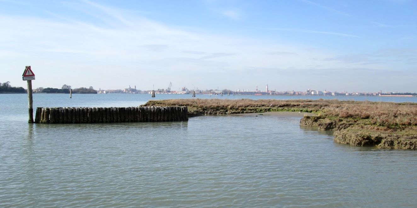
He proposes gouging out the mudbanks between the island of Sant’ Erasmo and the inlet at San Nicolo’, an area known as bacan’ (bah-KAHN). On the map, it looks like useless empty space longing for a purpose in life. But it already has a purpose — two of them.
This view shows the lagoon inlet at San Nicolo' on the left; in the middle is the island created for the MOSE project, which has already affected tidal behavior. "Bacan'" is the beige area in the big channel to the right, a swath of mudbanks with a temporarily exposed islet fronting the lower edge of the island of Sant' Erasmo. (Photo: Chris 73, Wikimedia Commons).
Its first purpose is the same as that of similar areas which compose the bloody-but-unbowed natural lagoon ecosystem. Mudbanks and barene, the remnants of marshy wetlands scattered around, are an essential component of the lagoon environment. You may not care about clams and herons and glasswort, but these formations also slow the speed of the tide, something that ought to interest people ashore in the most-beautiful-city at least as much as the vision of a ship heading toward the fondamenta.
Its second purpose is as one of the all-time favorite places for thousands of pleasure-boaters to spend long summer days swimming and clamming and picnicking.
Doesn't this look neat and tidy? Eight ships all snugged up together. While constant dredging would undoubtedly be required to keep the area from refilling with sand and mud, that effort would be helped by the vortexes created by cruise-ship propellers. (Photo: Il Gazzettino)
But according to Falconi, the creation of a basin where nature never put, or wanted, or intends to keep one, would be the perfect place to park the cruise ships. Ergo, there would also have to be the construction of a huge jetty.
As simple geometry, it looks okay, though I failed geometry. But apart from the problems the size, weight, and propeller-power those eight little rectangles represent, there is also the inconvenient fact that Sant’ Erasmo is an island, raising the issue of by what means the floating Alps of the sea would be provisioned, and how the passengers would arrive and depart.
Simple: By boat. Thereby increasing by several powers of ten the amount of waves (motondoso) caused by the multiplied number of motorized craft running around the area (barges, taxis, launches, and scows carrying trucks). Motondoso has already damaged a lot of the lagoon, so this new activity would eradicate a new chunk of what’s left. The summer motorboats are already sufficiently destructive — why would even more be seen as a good thing?
This idea is yet another example of the point where Feasibility and Desirability break up, despite the best efforts of people with assorted motives to make them get married and have children.
The "Ruby Princess" backing out of its berth at Tronchetto, like its companions, scours up a lot of sediment, not all of which settles back where it came from.
The following letter to the Gazzettino (March 29, 2012) gives an excellent analysis of this suggestion (translated by me):
LAGUNA CROCIERE E GRANDI NAVI (Lagoon, cruises, and big ships)
I read in the Gazzettino of the new proposal to “save” the cruises.
One appreciates the fantasy that unfortunately is right in step with the temerity of certain choices which we see at all institutional levels in the management of this problem.
To excavate bacan’ at Sant’ Erasmo to make it feasible for the big ships to maneuver and moor, ships which are tending to get bigger, would signify changing the hydrodynamics of the North Lagoon.
The creation of the new island in front of the inlet (at San Nicolo’) has already caused an increase in the velocity of the incoming tide, creating hydrodynamic imbalances with important consequent damage to the city.
To create a basin of 12 meters (40 feet) deep, at the least, to move and accommodate ships would make even that piece of lagoon into a piece of the sea.
Perhaps the fanciful pilot who has come up with this “loveliness” has forgotten about the abyss in front of San Nicolo’ with the resulting collapse of the bastions of the Fort of Sant’ Andrea a few years ago.
One understands that unfortunately the mentality still hasn’t changed: One tries to resolve a problem creating others. Or to put it this way: the application of the theory that has created MOSE: one creates a “solution” which, to talk about it, resolves the effects but not the cause.
The question arises spontaneously: Is the port worth the city?
(signed) Manuel Vecchina, Venezia
Excellent question, but don’t put it to Falconi. He’s already got the answer.
Here's a view of the area where the eight ships would park, with Sant' Erasmo in the background. Low tide reveals how much mud and sand there is, and how far below the surface it is. Guess Vittorio Orio will have to find another place to work on his mascareta, to make room for the Queen Victoria, the Norwegian Gem, and so on.A winter view of the same area, seen from the shore of Sant' Erasmo. It may look empty, but you should just see how much life there is bustling around in there.And here's a glimpse of how much life is bustling around the surface on a typical summer day here. Actually, this is nothing -- there are boats anchored all over bacan'.Egrets like to eat too, but if the big ships move in, all this will wash out to sea and the birds will have to bring their lunch with them.By "big ships" I mean something like this.
The Venetian lagoon is one of the most important coastal ecosystems in the entire Mediterranean. A century ago there were 35 square miles of salt-marsh wetlands in the lagoon; due to erosion by motondoso and the tidal force increased by the Petroleum Canal, by 1990 there were only 18 square miles left. Now we have MOSE, the floodgates whose installation required extreme deepening of the inlets, creating even stronger tidal flows.
In little more than 30 years, some 25,000,000 cubic meters of sediment have been flushed out to sea. At the current rate of erosion, the World Wildlife Fund has estimated that by 2050 there will be no wetlands left. So Venice is spending masses of money to rebuild a batch of them where they’ve been eroded away. Where they will be eroded away again. Now we want a fantasy port to speed up the process which is turning the lagoon into a bay of the sea?
I sometimes think that if these people want to change the lagoon so much, why don’t they just drop a bomb on it, and get it over with?
The fort of Sant' Andrea was built in the mid-1500's to defend the approach to Venice from enemies entering at San Nicolo'. The cannon were placed at the waterline in order to blast out the hulls of any approaching enemy ships. At low tide the cement apron is easy to see.
The reference to the Fort of Sant’ Andrea in Vecchini’s letter recalls the fact that some years ago (even before MOSE) the force of the tide was eroding the island beneath this historic structure, and the walls of the entrance were beginning to sag and open up. Solution: Throw masses of cement on the shallow lagoon bottom in front of it to stop the slow-motion collapse. When we row past there, we have to avoid what is essentially a broad cement shelf reaching outward from the fort. Of course I’m glad it’s there. I’m just saying.
Venice wanted the ships, but playing with them and their effects is beginning to look a lot like getting into a game of strip poker with no cards at all.
The catastrophe of the Costa Concordia two weeks ago today has been a good thing in at least one (sorry, I mean only one) way: It has given a turbo-boost to the local opposition to allowing big cruise ships to slide past the Piazza San Marco like floating Alps.
By now, images of these behemoths and Venice have become as trite as Venice and acqua alta.
Just one example at random of a typical big ship coming to Venice. The top deck is lined with thousands of people, all making the same photograph of the Piazza San Marco. As far as I can tell, this is the main reason why the big ships insist on entering and leaving Venice by the Bacino of San Marco.
There was murmuring before, but the death of a ship and some of its people has created a good deal of commotion, not only in Venice but also at the national level, concerning the desirability of allowing these ships to come here. Needless to say, the political parties have all hoisted their shields and battle-axes and are ready for combat. And, as usual, the trumpet sounding the charge tends to drown out any other sound.
I’d like to review the main points, though I have to warn you that this subject, like most other subjects here, has become a mass of insanely knotted statistics and semi-statistics and facts and semi-facts interpreted in 11,552 different ways, according to who is speaking and, ergo. what they want. Debates of the pros and cons of heavy cruise ship traffic in the world’s most beautiful city and environs are so loaded with emotion that it has become virtually impossible to hear what anybody’s really saying, though the various viewpoints are fairly simple to summarize.
Cruise statistics for 2011 as published by the Gazzettino.
Pro: There is only one item in the “pro” column on the proverbial yellow legal pad, and that’s “Money.” Venice has done everything possible to attract and keep cruise business. In 2000, only 200 ships visited Venice, and it is now the Number One cruising homeport in the Mediterranean, and the third in Europe. With the shrinking of the income from the Casino, the starving city budget is being kept alive primarily by this new touristic medium.
Don’t be distracted by the number of companies whose ships come to Venice (43), or how many ships visited last year (654) or the number of transits they made of the Bacino of San Marco (1,308) — I’d have thought there were more — or the number of passengers last year (2,248,453), even though all these numbers are pretty impressive (fancy way of saying “huge and scary”).
The only number that matters to the city, and the only factor which virtually guarantees that cruising will continue to be crucial here, is the money the city earns from it: 300 million euros (US$390,246,000) last year.
If you want to object to cruising in or around Venice, you need to come up with a suggestion for some other activity that will make that kind of money. Or, preferably, even more. Feel free to get back to me on this.
A view of the docks at Tronchetto. As you see, seven assorted ships can fit in here at any one time, though these is space for smaller ones (yes, there are smaller ones) at the Zona Marittima nearby -- three are moored there in this picture, just to the right of the big docks. Discussion is underway to expand the dock area.
Con: The conscientious objectors to cruising offer many urgent reasons why it is deleterious to the city. These reasons are more or less persuasive, depending on how deeply their proponents have managed to bury their ulterior motives.
The two main items in the “con” column concern the environmental damage wrought by the floating Alps.
They are:
Erosion caused by waves (there are no waves) and/or by the suction of the motors. This suction is real: I can attest that the motors of these ships perform a phenomenal sucking/pushing action, very much like what happens to the mouthwash when you rinse your mouth. I have seen with these very eyes the waters surging in and then surging out as a ship passes, even if it passes at a distance. It’s hard to think that this could be unimportant. As we know from the humbler but more destructive daily motondoso, water going into a fissure in a foundation pulls something with it — soil, mainly — when it comes out. This eventually creates empty spaces under buildings and sidewalks.
Ships maneuvering to enter or back out of their berths also create massive suction, as the brown sediment churned up here attests.
A study done by Worcester Polytechnic Institute on the hydrodynamic effect of big ships found this: “As cruise ships pass smaller canals along the St. Mark’s Basin and Giudecca Canal, they displace and accelerate the surrounding body of water, essentially pulling water from the smaller canals. This caused a noticeable increase in canal speed and a drop in the water levels. A total of five velocity tests were completed resulting in a 57.4% increase in canal speed, and two canal height tests were completed which showed an average water level drop of 11 c (4.3 inches). The observations suggest that the root cause for these accelerations can be explained by the Bernoulli Effect: the colossal geometry of cruise ships creates fast currents and low pressure areas around the moving vessels.”
Particulate Matter, the form of air pollution made up of tiny bits of stuff from combustion exhaust. Nobody made an issue of this when Venice was a real industrial center, and nobody brought it up when the Industrial Zone on the shoreline was going full blast. Nobody made an issue of it, Lino points out, when everybody — everybody — heated their homes or cooked using wood or coal. “You didn’t need to smoke anything,” he said — “smoke was everywhere.” But particulate matter from the ships is intolerable.
The view of the Giudecca Canal as seen by the passengers on a departing ship. I'm on a Minoan Lines ferry to Greece. If a ship were to go rogue here it could endanger city on both sides.
Four days after the Concordia ran aground, Corrado Clini, the new Minister for the Environment, came to Venice for a day. He was shown a number of things (MoSE was not on the list, which I can understand, because nothing can be done about it now), but the subject on everybody’s mind was the big ships.
He offered the following opinion: “Common sense suggests that if the principle value to care for is our natural patrimony, the fundamental resource for our tourism, we must avoid that it be put at risk.” You can’t argue with that.
He continued: “The traffic of these ‘floating apartment buildings’ in the Bacino of San Marco, with a notable impact, are without utility for the environment and for tourism.” If he is seeking utility for tourism, all he has to do is look at the municipal balance sheet. However, “without utility for the environment” is hard to refute.
Luca Zaia, the President of the Veneto Region, who was on hand, remarked that “The big ships in Venice are dangerous and certainly a problem to resolve. I have to admit that to see these colossi at San Marco is, to say the least, horrifying.” I myself have to admit that it’s odd that he only became horrified after the Concordia ran aground; the ships have been passing for years.
Giorgio Orsoni, the mayor of Venice, contributed these observations: “The subject of the big ships is an open one. With the Port Authority we have begun to reflect on a rapid solution which will satisfy the touristic system as well as the economic one.” Rapid solutions are not easy to come up with, because every player wants his concerns to come first. Nor would a rapid solution instill much confidence. If complex, well-reasoned solutions haven’t been found yet, why would a rapid one be any easier to devise, much less implement?
Sandro Trevisanato, president of VTP, which runs the port, stated that the big ships are the least polluting form of tourism, adding that the buses, the big launches, and cars create much more pollution than the big ships. (For the record, I’d like to say that this is the most intelligent comment so far.) He points out that emissions are one of the arguments used by those who want to ban the cruise ships from the lagoon, far beyond the aesthetic question. It’s a question of taste,” says Trevisanato. “In a few seconds the ships have passed and disappear.” Seconds? Has he never stood on the embankment on a summer Sunday evening to watch the March of the Pachyderms as they depart? Even one ship, by my estimate, takes at least 45 minutes to pass from Tronchetto to Sant’ Elena. And there could easily be seven of them, virtually nose to tail.
In any case, everybody directly involved in cruise tourism agrees that pollution must be kept at “level zero.” How to do that isn’t explained.
As for the possibility — remote, all agree — that something could go wrong with the motors, or that the ship for some other reason would suddenly become ungovernable, and that the force of inertia would impel it to ram bow-first into the Piazza San Marco or some other bit of Venice, Trevisanato says that the port is one of the most secure in the world, as the ships are protected from the effect of wind and waves, and the ships pass at a reasonable (I put that in) distance from the shores. Hard to say what is “reasonable” when the Giudecca Canal is only 320 meters (1000 feet) wide, or less. But you will have noticed that referring to wind and waves prevented him from discussing the consequences of a big ship going adrift in the Bacino of San Marco.
Someone reminded him that in 2004 the ship “Mona Lisa” ran aground in the fog in the Bacino of San Marco. His reply: “Exactly: and nothing happened.” This is true; the ship was on its way after a mere hour, undoubtedly thanks to the help of the rising tide. But the “Mona Lisa” is 201 meters (609 feet) long by 26 meters (85 feet) beam, and a gross tonnage of 28,891; not exactly a floating Alp.
The Concordia was 292 meters (958 feet) x 35.5 meters (116 feet); gross tonnage 112,000.
In any case, saying “Nothing happened” isn’t very helpful. It brings to mind the famous exchange in a Ring Lardner story: “‘Daddy, are we lost?’ ‘Shut up,’ he explained.”
The "Mona Lisa." This is what most cruise ships used to look like, before they put them on steroids.
And the mayor’s statement that a “rapid solution” is in the works isn’t very reassuring, even if it were true. Solutions have been debated for years.
Proposed solutions so far:
Building an “offshore port” in the Adriatic where the floating Alps would tie up, and offload passengers (and luggage) into launches which would bring them to Venice. Objections: Cost, feasibility, and the obvious pollution, primarily motondoso, which would be caused by thousands of launches trundling to and fro all day. I can add the element of potential danger to people, if not to Venice, of boarding and traveling in a launch when the bora is blowing.
Make the Bacino and the Giudecca Canal a one-way street. Tourists get to snap the Piazza San Marco either coming or going, but not both. This has the advantage of not depriving them totally of this scenic opportunity, while cutting in half the number of transits. A tour operator told me that it isn’t uncommon for a potential cruise customer to ask if the ship passes in front of the Piazza San Marco. If the answer is no, it’s an immediate deal-breaker.
Bring the ships into the lagoon via the inlet at Malamocco. Heavy shipping already passes here, heading for the docks at Marghera, so more heavy ships wouldn't make any difference. Theoretically.
But this new system would require deepening a heretofore unimportant natural channel known as the Canal of Sant’ Angelo in order to create a sort of bypass. Enter the lagoon at the inlet at Malamocco, steam up the shoreline via the Petroleum Canal, then turn right in the Canal of Sant’ Angelo, which neatly brings the behemoth to Tronchetto. The ship would depart via the Giudecca Canal, so the passengers could all snap their photos.
Or, the ship would enter, as it does now, by the inlet at San Nicolo’, steam past San Marco (snap snap snap) to Tronchetto, then depart down the Canal of Sant’ Angelo, Petroleum Canal, and out into the Adriatic at Malamocco.
Sometimes a big ship moors downstream from San Marco at the Riva dei Sette Martiri. It might seem like a bright idea to put them all here, except that the passengers wouldn't get their snaps; also, there isn't enough shoreline for the typical job lot on a summer weekend. And there is also the issue of the vibrations from the generators and the blocking of television reception which are major irritations for the residents. Who would want to spend the summer with these just outside the front door?
What’s extremely wrong with this idea — in my opinion, as well as many environmentalists — is that deepening the Canal of Sant’ Angelo would be a reprise of the digging of the Petroleum Canal, a deed which many have long since recognized as a disaster for the lagoon. A channel as straight as an airport runway and deep enough for cargo ships and tankers behaves like the average water faucet, concentrating and accelerating the force of the water passing through it. Many environmental groups date the beginning of the deterioration of the lagoon ecosystem from the creation of the Petroleum Canal. Among other things, it is estimated that this canal is responsible for the loss of one million cubic meters of sediment every year. We don’t have to care, but the myriad creatures and plants which depend on the sediment certainly do.
Digging another deep channel will almost certainly cause the same phenomenon, thereby multiplying the damage. Just what we need, when you add in the same effect caused by the deepening of the three lagoon inlets for the installation of the MoSE floodgates.
So the bypass canal, which looks so good on paper, would be yet another blow to an ecosystem which UNESCO, along with the city of Venice, designated as a World Heritage Site. Now that I think of it, the only group that hasn’t weighed in yet on this is UNESCO. Maybe they’re thinking.
Last idea: Forget Tronchetto. Move the whole passenger port over to the shoreline at Marghera. Docks already exist, or could be created, so logistically the idea has a lot in its favor. Except that Marghera is part of the dying Industrial Zone, with all the aesthetic appeal of a dying Industrial Zone. It’s like selling a cruise from Venice that actually starts in the Port of Newark or Liverpool. Intending no offense.
Speaking of the force of inertia, debates, meetings, commissions, studies (oh good, we can always use more of those) and assorted pronouncements will undoubtedly continue. I can make that claim because when the “Mona Lisa” ran aground in 2004, the then-mayor, Paolo Costa, ringingly declared that a stop must be put to the big ships passing in the Bacino of San Marco.
He said (translation by me): “What happened has unfortunately confirmed my worries, and that is that an absolute certainty doesn’t exist on the possibility to guarantee the security in this zone of the city (Bacino San Marco) which is so important and delicate. It was horrifying to see the ship aground a mere 30 meters from a vaporetto stop, and fortunately consequences were avoided that could have been disastrous and unimaginable. Now we must take rapid measures, more than one, and very detailed, that eliminate the danger of finding, one day, a ship in the Piazza San Marco. Because everything which today is at risk in the Bacino of San Marco isn’t something that can be protected only probably, but certainly, and with safety.”
Eight years have passed, two mayors have succeeded him, Costa is now President of the Port of Venice, and those “rapid measures” are still being fervently invoked.
The Port of Venice may be protected from potentially dangerous winds, but there seems to be no way to protect it from hurricanes of hot air.
A big ship leaving Venice. These proportions once shocked and dismayed me. But you can get used to almost anything.