Yes, there has been more than one aqueduct. There is the current one, which was inaugurated in 1884 and is still functioning with 30 percent of its original cast iron pipes. And there was the first one, begun in 1425 and working until 1884. This is the one that in my opinion deserves our astonishment and admiration, seeing that the duct for the aqua was boats, buckets and men.
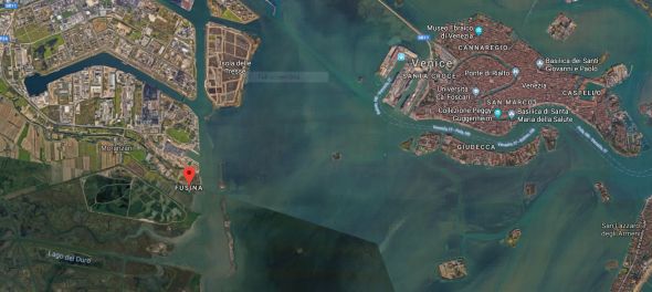
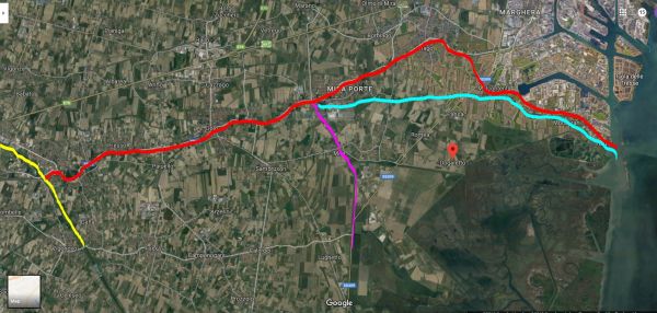
A view of Fusina, watery gateway to the Venetian hinterland a mere 4.4 km / 2.7 miles from Venice.Let me set the scene. This is a view of what the Venetians accomplished in order to get their water supply from the Brenta River. The yellow line is the Brenta today. The red line is its original, natural riverbed, which empties into the lagoon at Fusina (anciently called “Lizzafusina”). The Brenta couldn’t be permitted to rampage all the way into the lagoon along its original path (red) because of the difficulty in managing a wild river, and because it presented a clear danger of silting up the lagoon in that area. So the Venetians re-routed the Brenta southward to get it out of the way, essentially, and used the old watercourse as a more domesticated and manageable stream, naming it the Naviglio del Brenta, or navigable Brenta. As if that weren’t enough rockstar water wrangling, they later cut another channel (fuchsia) called the “canale Novissimo” (super-new canal) in order to manage the waterflow in the Naviglio. But by the early 1600’s it was clear that the water in the Naviglio wasn’t reliably clean enough for continued drinking, so in 1609 the “Seriola” channel (teal) was cut. It debouched at Fusina just as the Naviglio did (and still does), but this stretch of water was stringently checked for any possible sources of pollution (soap from laundry, farm runoff, trash, etc.). Today the Seriola is reduced to a dribbly little stream that disappears along the way, not even a shadow of its former glory. Zoom in on google maps and you can follow these channels as they are today.
First, some background: At the beginning of the 14th century, Venice was one of the most populous cities in Europe, with some 200,000 inhabitants. Which meant that when the plague struck in 1348, there were plenty of victims. On the positive side, this reduction of thirsty mouths meant that the survivors now had plenty of water on hand in the wells. On the negative side, a comprehensible terror of contamination had set in which made people reluctant to use them. Supplementary water had been brought for years from nearby rivers but now that, too, had become suspect.
You may have noticed that Venetians were not, generally speaking, an easily daunted people. They built palaces on mudflats awash in brackish tides, to take an example at random. So a problem presented itself: Need more fresh water. A solution was born: Pick one river, keep it clean, harvest the water and bring it from there to the city.
That decision made, in 1425 the health department decreed that the Brenta would be the only river to be used for drinking water. (Among its many fine points was its nearness to the city.) Laws and regulations were enacted to protect its purity, and a system devised by which river water was loaded onto boats that were rowed, of course, or sailed, if possible, to Venice; there the water was transferred into smaller boats and then finally into the wells, public and private. (Not directly into the wells, of course, but down the gatoli so that the water would benefit from the same filtering process as rainwater.) After which it was paid for, naturally. This is Venice, where money is king.
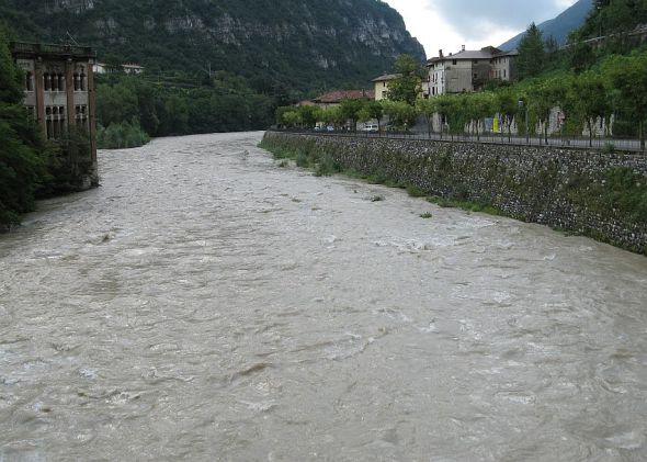
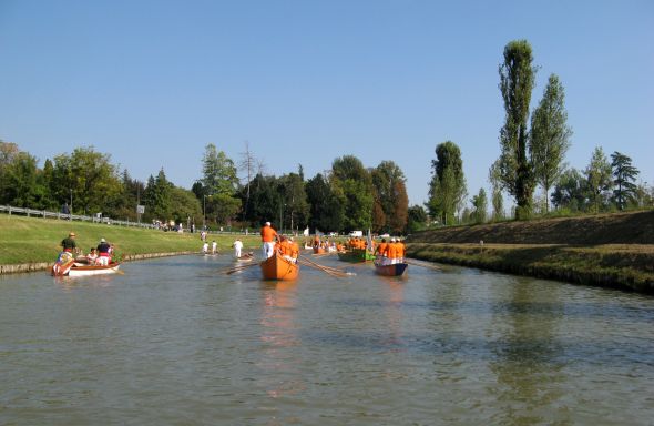
The Brenta River rises in the lake of Caldonazzo inland 144 km (89 miles) toward the Alps, here shown at Carpane’-Valstagna in the Sugana valley. True, that day it had rained heavily in the mountains so the river was fairly unruly, but rain and snow are what one hopes for if one is waiting for water downstream. I think it’s clear that a river that looked even somewhat like this at the lagoon edge would not be anyone’s first choice, even apart from the question of how much soil it’s carrying. On that day it was carrying a lot.The Naviglio is the domesticated branch of the Brenta reduced to manageable dimensions, here hosting the “Riviera Fiorita,” an annual day-long boat procession from Stra to Moranzani. Notice the remains of the towpath along the right-hand bank.
And so the acquaroli (acquaioli in Venetian) or watermen, once minor figures in the drama of Venetian water supply, became lead players, and formed their own guild in 1471. They rowed (I keep stressing that, but they also sailed) thousands of liters of water to Venice in enormous cargo boats still called burci (singular: burcio). If they carried only water, it was poured into the burcio itself, indubitably into compartments; if any enterprising acquaroli used their boat on off days to haul garbage away, they were required to carry the water in specially designed tubs. (As if that needed to be specified?)
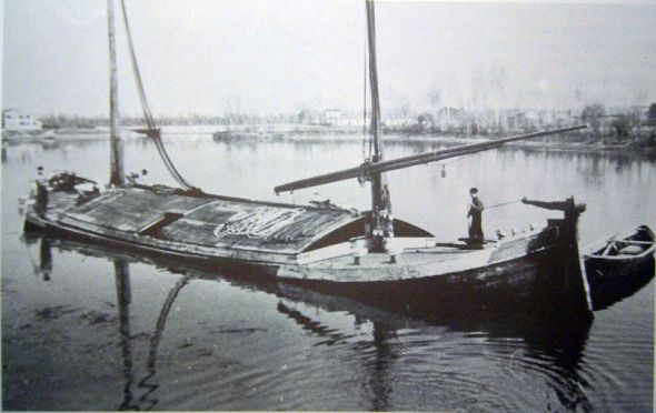
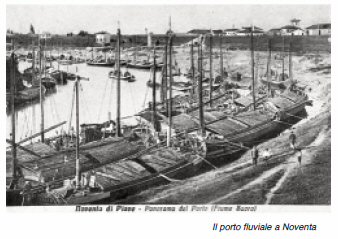
This is a burcio in 1948, which as you see was rigged for sailing whenever possible. The crew lived aboard in the spaces beneath the bow and stern. The cargo here was sand. (Photo: nauticautile.altervista.org). And yes, they rowed them when necessary. Lino says that they always had a smaller boat tied astern.The burci were riverboats, definitely not designed for the sea. This is the port of Noventa on the Piave river; Lino remembers when burci like these would be moored in the same way along the Zattere.A burcio entering the lock at Moranzani, the last one on the Naviglio before reaching Fusina. Boats here typically were towed along a towpath by animals — oxen, mules, horses, or if there was nothing else, by men. The boatmen would often have a dog, and you can imagine it; what we might call a “junkyard dog” comes out, even today, as calling something or someone a “can da burcio” — a burcio dog.
Given the importance of their cargo, the guild of the acquaroli was overseen by not one, but several government agencies: The “Giustizieri Vechi,” “Provedadori sora la Giustizia Vechia,” “Magistrato a la Sanità” (health) and “Colegio a la Milizia da Mar.” The men were also required to make various payments to the noble families which had been granted the concession to maintain what became an impressive industrial complex.
The acquaroli had to keep a sharp eye on their product, because there were laws forbidding the use of public water for private gain. There were many water-intensive crafts in Venice — dyeing, wool-washing, laundry-washing, glass-making, to pick a few, and they were required to buy their own water. The acquaroli were authorized to stand guard on the public wells to make sure any private entrepreneurs didn’t treacherously attempt to steal the water for which the city had paid. They watched the wells out of the goodness of their hearts? Not really. Water in the public wells was paid at a lower rate than the private wells, so the acquaroli had a vested interest in making sure the cheap water wasn’t being removed by the expensive-water customers.
There was also a subset of some additional 100 acquaroli who didn’t belong to the guild. They were illegal but that didn’t bother anybody; they had their own waterboats and were permitted, for an annual fee of 20 soldi paid to the guild, to sell their water retail to any customer standing there with a bucket or pot.
When the burcio arrived at its established destination in the city, the water would be offloaded onto smaller boats which were then rowed to whatever wells were on the schedule to be filled that day.
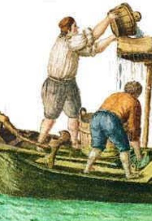
Two acquaroli pouring the fresh water from their smaller boat down a wooden trough which emptied into the gatoli of whatever well they were hired to fill. Unhappily I haven’t found any other illustrations of this process. This pen-and-ink- plus-watercolor depiction is by Giovanni Grevembroch (1753).
How the water got to Venice is one thing, but how the water got to the burci is an even more impressive tale.
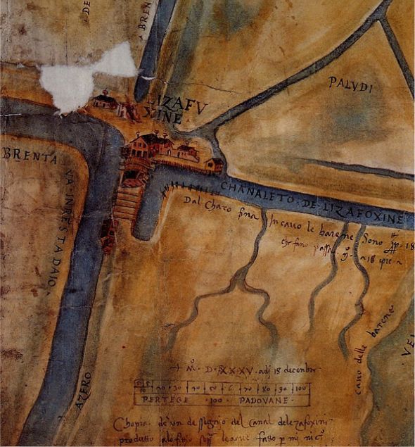
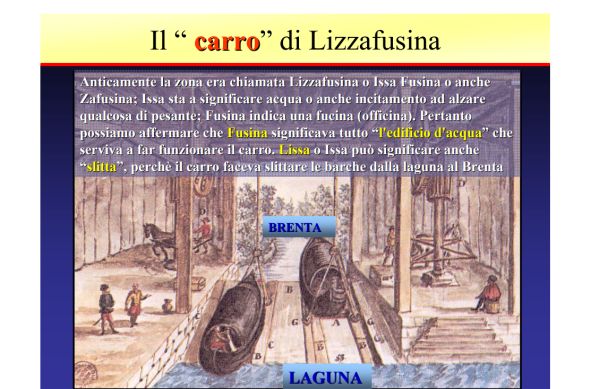
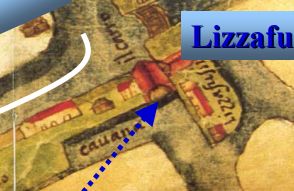
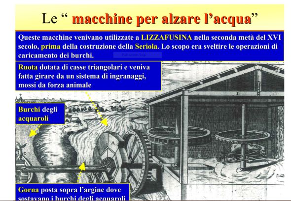
A drawing of Lizzafusina in 1500 by Nicolo’ Dal Cortivo. The “chanaleto de Lizafoxine” leads to the right (eastward) and was the channel by which any and all boats arrived at Fusina.This was the set-up at what was originally called Lizzafusina, but now is simply Fusina. We’re looking upstream, obviously. This and the following four historical drawings are from a PowerPoint presentation by A.A.T.O. Consiglio di Bacino Laguna di Venezia prepared by engineer Tullio Cambruzzi. (Caption translated by me): “The ‘carro’ (wagon) of Lizzafusina. In the old days the zone was called Lizzafusina or Issa Fusina or also Zafusina: Issa signifies … an urging to raise something heavy” (as in “haul away!”); “Fusina indicates an ‘officina’ (workshop). Therefore we can affirm that Fusina signifies the entire “water building” that served to make the carro function. Lissa or Issa could signify also “slitta” (sled), because the carro made the boats slide from the lagoon at the Brenta.” Evidently this system functioned to raise (and presumably lower) boats between the lagoon and the Naviglio until the lock was dug slightly upstream at Moranzani about 1613. The fees for maintaining this installation, the duties and excise fees paid by commercial traffic passing from the mainland to the lagoon went to a part of the Pesaro family, who were usefully nicknamed the “Pesaro del Caro,” or “of the carro.” When the lock was built it put the “carro” out of business, and the Pesaros were given the operation at the lock at Moranzani instead; in 1649 alone it earned them 1530 ducats.A close-up of the red-roofed building that housed the “carro,” into which the burci entered from Venice (direction lower right).“The machines to raise the water –These machines were used at Lizzafusina in the second half of the 1500’s before the construction of the Seriola. The purpose was to make the operation of loading the burci more efficient. The wheel (A) was fitted out with triangular boxes which were made to turn by a system of gears moved by animal power.” The water is being discharged into a trough leading to the waiting burcio (far left).
The system itself worked well, but by the early 1600’s the Venetian government had to admit that despite efforts to ensure its potability, the water from the Brenta was not always of the most limpid. So Cristoforo Sabbadino, a hydraulic engineer, was engaged as the head of a team to build a better system. (Let it be noted that the idea was totally his, and he’d been proposing it for years before the government finally agreed to undertake the project.)
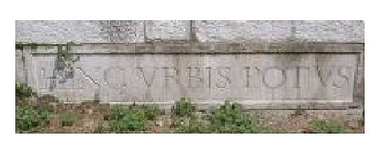
Between 1609 and 1611 Sabbadino cut a channel, the “Seriola,” from the Brenta upriver at Dolo. This was now to be the official drinking-water supply for Venice and was so marked at that point by a marble tablet inscribed “HINC URBIS POTUS (“this is the potable water for the city”). The Seriola was 13.5 km long and one meter wide (8.3 miles and 3.2 feet), and brought the water downstream to the lagoon edge at Moranzani, having been passed through a series of filtering tanks. The Seriola’s quality was overseen by the Savi Esecutori alle Acque, and anyone caught besmirching its crystal depths was subject to heavy fines.
This historic marker still exists, but one source says it’s on via Garibaldi in Dolo, and another says it’s in the Dolo city hall. Anyway, it’s somewhere. Someday I’ll get to the bottom of this. “Seriola,” or Ceriola, was an ancient Venetian term meaning a small or narrow watercourse.
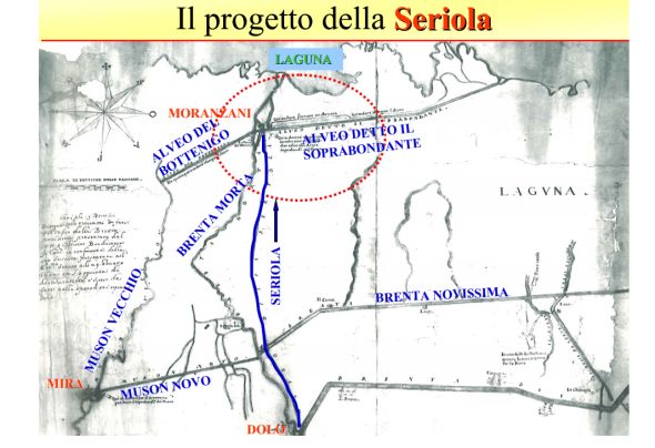
Here is the scheme for the Seriola:
Note that the top of the image is east. (“Alveo” means riverbed.) Working from the top clockwise we see “Riverbed called the Soprabondante” (“super-abundant,” known today simply as the Bondante); Brenta Novissima, which is the fuchsia line on the map at the beginning of this post and now called the “super-new canal”; the Muson Novo, or new Muson River clearly dug between the Seriola and the Muson Vecchio,” or old Muson, and riverbed of the Bottenigo River. The “Brenta Morta” or “dead Brenta” indicates the Naviglio which has been sidelined from the water-supply game.
So the water flows down the Seriola until it nears the lagoon’s edge.
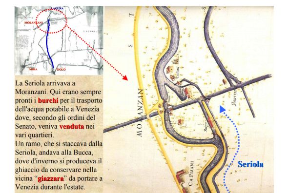
“The Seriola arrived at Moranzani. Here there were burci always ready to carry the potable water to Venice where, according to the orders of the Senate, it was sold in the various districts. A branch of the Seriola went to the Bucca, where in the winter ice was produced and conserved in the nearby “giazzara” to be carried to Venice in the summer.” I don’t see either of those components on this map, so we will just have to imagine it.
Trust me, this post contains only the most minuscule part of the water-management system devised and maintained by the Venetians, and if I had time I’d have read more and basically kept the story going indefinitely. But anyone who might be even momentarily tempted to consider the construction of MOSE something impressive should pause to reflect on what was involved in moving all these rivers around. Which had become something of a Venetian specialty; in the same period (1600-1604) they also cut the Po River at Porto Viro and detoured it in a similar way to avoid imminent silting-up of the lagoon near Chioggia. The Po is the largest river in Italy. But as I may have mentioned, the Venetians were virtually impossible to daunt.
Water, we take it so for granted, until it’s not there. How ingenious, and hard working, these people were, to try to ensure a supply of that precious fluid.

2 Comments
Water, we take it so for granted, until it’s not there. How ingenious, and hard working, these people were, to try to ensure a supply of that precious fluid.
Thank you, Ms Wordsmith.
Well, it was either that or move away. I’m in awe of how they just got down to business and solved problems.